台風23号被災水深
Location: 豊岡市
Color: aqua
GPS coordinates: 35.65217,134.76328
Latest update: November 18, 2025 22:17
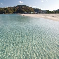
Takeno Beach
1.1 km
Kitamaekan
1.2 km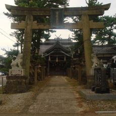
Takano-jinja
886 m
Wayside shrine
1 km
Wayside shrine
863 m
Statue, Work of art
753 m
Statue, Work of art
861 m
Statue, Work of art
862 m
Statue, Work of art
877 m
Wayside shrine
646 m
長命地蔵
624 m
Wayside shrine
617 m
Memorial stone, memorial
872 m
Wayside shrine
2 km
庵蛇浜
1.3 km
Wayside shrine
1 km
弁天浜海水浴場
1.1 km
柴栗山睨満の碑
1.5 km
立江地蔵尊
1.7 km
Wayside shrine
764 m
Tomb
2 km
Wayside shrine, Buddhism
665 m
Buddhism, wayside shrine
876 m
Wayside shrine, Buddhism
730 m
今坂地蔵尊
1.3 km
仲田光成先生書碑
634 m
竹野保育園
756 m
Memorial
895 mReviews
Visited this place? Tap the stars to rate it and share your experience / photos with the community! Try now! You can cancel it anytime.
Discover hidden gems everywhere you go!
From secret cafés to breathtaking viewpoints, skip the crowded tourist spots and find places that match your style. Our app makes it easy with voice search, smart filtering, route optimization, and insider tips from travelers worldwide. Download now for the complete mobile experience.

A unique approach to discovering new places❞
— Le Figaro
All the places worth exploring❞
— France Info
A tailor-made excursion in just a few clicks❞
— 20 Minutes