Wayside shrine
Location: Jausiers
Inscription: V
GPS coordinates: 44.42030,6.73316
Latest update: November 10, 2025 15:54
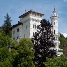
Château des Magnans
821 m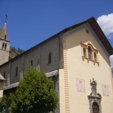
Église Saint-Nicolas-de-Myre de Jausiers
85 m
Église Sainte-Catherine de La Condamine-Châtelard
4.4 km
Sommet de Vallon-Long
4.4 km
Scenic viewpoint
2.3 km
Scenic viewpoint
106 m
Catholic church building, wayside cross
379 m
Wayside shrine
13 m
Wayside cross
46 m
Wayside cross
3.8 km
Catholic church building, wayside cross
259 m
Wayside shrine
2.4 km
Catholic church building, wayside cross
2.6 km
Catholic church building, wayside cross
4.3 km
Maison de Pays de l'Ubaye
409 m
Wayside cross
431 m
Wayside shrine
32 m
Belvédère du Châtelard
3.6 km
Wayside shrine
23 m
Wayside shrine
29 m
Wayside shrine
31 m
Wayside shrine
18 m
Wayside shrine
39 m
Wayside shrine
26 m
Wayside cross
2.3 km
Memorial, war memorial
97 m
Memorial, war memorial
4.3 km
Waterfall
4 kmReviews
Visited this place? Tap the stars to rate it and share your experience / photos with the community! Try now! You can cancel it anytime.
Discover hidden gems everywhere you go!
From secret cafés to breathtaking viewpoints, skip the crowded tourist spots and find places that match your style. Our app makes it easy with voice search, smart filtering, route optimization, and insider tips from travelers worldwide. Download now for the complete mobile experience.

A unique approach to discovering new places❞
— Le Figaro
All the places worth exploring❞
— France Info
A tailor-made excursion in just a few clicks❞
— 20 Minutes