Lame Rosse inizio percorso

Log in to your account

AroundUs is a community-driven map of interesting places, built by curious explorers like you. It grows with every review, story, and photo you share.
Connect to save your favorite spots, contribute locations, and create personalized routes.
Continue with Google
Continue with Apple
Continue with X
Continue with Facebook
Continue with email
By continuing, you accept our Terms and Conditions and our Privacy Policy
Create an account

Lame Rosse inizio percorso

Add to collection
Map
Suggest a change
Share

Lame Rosse inizio percorso

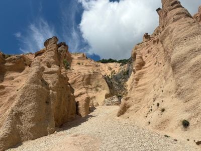
The Lame Rosse start is a hiking trail in the Sibillini National Park located in the Fiastrone Valley above Lake Fiastra in the Marche region. The trail begins at the dam and runs for about 3.5 kilometers uphill through an oak forest to reach red rock formations made of gravel, clay, and silt that create towers and spires.

The area has been used since ancient times by hikers who used the red rocks as natural landmarks for navigation. The Fiastra dam was built in 1955, creating the modern lake, while the rock formations themselves are the result of long natural erosion caused by wind and water over time.

The red rocks take their name from their distinctive coloring, which comes from iron oxide and varies from red to ochre depending on the time of day. For the local community of Fiastra, these formations are part of the natural identity of the region and are often mentioned in stories about the landscape.

The parking area is located about 500 meters from the start of the trail and is easy to reach on foot. The area has no access to water or refreshments along the path, so bring plenty of water and snacks with you.

Birdsong and wind sounds are frequently heard during the hike, and visitors sometimes report seeing signs of wild animals near the rocks. These sounds and signs of wildlife create a direct connection with the living landscape.

Address: Strada Provinciale 91, 3, 62035 Fiastra MC, Italy

Website: https://amarche.it/prov/macerata/sentiero-lame-rosse-diga-lago-fiastra

GPS coordinates: 43.06042,13.18522

Latest update: January 13, 2026 09:05

Photos
Marche in Italy: UNESCO heritage, natural parks and the Adriatic coast

The Marche region in central Italy stretches between the Apennines and the Adriatic Sea. This collection brings together places that let you explore the area: towns of art like Urbino and Ascoli Piceno, natural parks in the mountains, underground caves at Frasassi, seaside resorts along the coast,...

Reviews

Visited this place? Tap the stars to rate it and share your experience / photos with the community! Try now! You can cancel it anytime.

« Lame Rosse inizio percorso » is provided by Around Us (aroundus.com). Images and texts are derived from Wikimedia project under a Creative Commons license. You are allowed to copy, distribute, and modify copies of this page, under the conditions set by the license, as long as this note is clearly visible.

Discover hidden gems everywhere you go!

From secret cafés to breathtaking viewpoints, skip the crowded tourist spots and find places that match your style. Our app makes it easy with voice search, smart filtering, route optimization, and insider tips from travelers worldwide. Download now for the complete mobile experience.

Around Us App Screenshot

A unique approach to discovering new places

Le Figaro

All the places worth exploring

France Info

A tailor-made excursion in just a few clicks

20 Minutes