Enable Location

We need your location to show you interesting places around you

Discover nearby places

Find interesting locations and hidden gems around you

Precise directions

Get accurate directions and distances to places

Your location is never shared with other users. It's only used when you tap the location button.

Žampach viaduct

Log in to your account

Start exploring — it's free

Trusted by 65,055 travelers worldwide

Continue with Google
Continue with Apple
or

We will send you a code to connect

By continuing, you accept our Terms and Conditions and our Privacy Policy

Check your inbox

We've sent a pincode in your inbox. Please enter the code below.

Discussion Reviews 1 Photos
5.8k Popularity

Žampach viaduct, Railway bridge in Luka pod Medníkem, Czech Republic

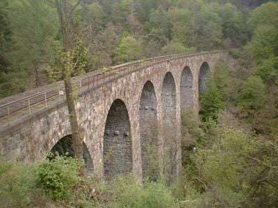
The Žampach viaduct is a stone railway bridge in Luka pod Medníkem, Czech Republic, built with seven arches that span the Kocour gorge. Made from granodiorite, it runs about 109 m (358 ft) long and rises roughly 42 m (138 ft) above the Studený stream below.

Construction of the viaduct started in 1898 and was finished in 1900, with Italian workers brought in to build the railway infrastructure. Its completion opened up a continuous rail connection through this remote corner of Bohemia.

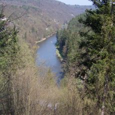
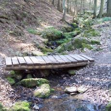
The viaduct is part of the Posázavský pacifik railway line, a name coined by local hikers in the 1920s. The line runs through narrow valleys and draws both railway enthusiasts and walkers who follow the trails along the tracks.

The best views of the viaduct are from the trails that run along the gorge or from nearby viewpoints above the valley. The terrain is steep in places, so sturdy footwear is a good idea before setting out.

Since its completion in 1900, the viaduct has needed no major repairs, which is rare for a structure of this age and size. The granodiorite used in its construction was sourced locally, which likely contributed to how well it has held up over time.

The community of curious travelers

AroundUs brings together thousands of curated places, local tips, and hidden gems, enriched daily by 60,000 contributors worldwide.

Start exploring
Inception
1898
Official opening
May 1, 1900
Height
41.73 m
Length
109.33 m
Made from material
stone, granodiorite
GPS coordinates
49.87306,14.48777
Latest update
March 3, 2026 10:09
Around this place
Saint Adalbert of Prague Church (Jílové u Prahy)
Czech Republic

Saint Adalbert of Prague Church (Jílové u Prahy)

2.4 km
Štola sv. Josefa
Czech Republic

Štola sv. Josefa

287 m
Štola sv. Antonína Paduánského
Czech Republic

Štola sv. Antonína Paduánského

164 m
Raisova vyhlídka
Czech Republic

Raisova vyhlídka

2.2 km
Štola Halíře
Czech Republic

Štola Halíře

2.2 km
Chapel of Saint Anne in Jílové u Prahy
Czech Republic

Chapel of Saint Anne in Jílové u Prahy

1.7 km
Lávka Posázavské stezky přes potok od Třebsína
Czech Republic

Lávka Posázavské stezky přes potok od Třebsína

2.3 km
Jilm vaz u hájovny v Turyni
Czech Republic

Jilm vaz u hájovny v Turyni

2.1 km
Church of Saint Ludmila in Kamenný Přívoz
Czech Republic

Church of Saint Ludmila in Kamenný Přívoz

1.9 km
Pinkoviště Halíře
Czech Republic

Pinkoviště Halíře

2.2 km
Usedlost čp. 10
Czech Republic

Usedlost čp. 10

2.3 km
Jírovec u Včelního Hrádku
Czech Republic

Jírovec u Včelního Hrádku

445 m
Ovčínské vodopády
Czech Republic

Ovčínské vodopády

1.2 km
Žampašská vyhlídka
Czech Republic

Žampašská vyhlídka

318 m
Lípa u Zlatého potoka
Czech Republic

Lípa u Zlatého potoka

1.3 km
Třebsínský vodopád
Czech Republic

Třebsínský vodopád

2.2 km
Wooden wayside cross in Jílové
Czech Republic

Wooden wayside cross in Jílové

2.4 km
Usedlost čp. 3
Czech Republic

Usedlost čp. 3

2.3 km
Bridge in Kamenný Přívoz
Czech Republic

Bridge in Kamenný Přívoz

1.8 km
Plaque of Jan Hanuš
Czech Republic

Plaque of Jan Hanuš

2.3 km
Buk na Včelním Hrádku
Czech Republic

Buk na Včelním Hrádku

521 m
Klimentova vyhlídka
Czech Republic

Klimentova vyhlídka

2.3 km
Lávka Posázavské stezky přes potok od osady Úsvit
Czech Republic

Lávka Posázavské stezky přes potok od osady Úsvit

2.3 km
Kříž západně od cesty nad Včelním hrádkem u Jílového
Czech Republic

Kříž západně od cesty nad Včelním hrádkem u Jílového

689 m
Kříž východně od cesty nad Včelním hrádkem u Jílového
Czech Republic

Kříž východně od cesty nad Včelním hrádkem u Jílového

692 m
Kříž na Boží skále u Jílového
Czech Republic

Kříž na Boží skále u Jílového

2.2 km
Kříž u hájovny Turyň
Czech Republic

Kříž u hájovny Turyň

2.1 km
Kříž jihozápadně nad Jílovým u Prahy
Czech Republic

Kříž jihozápadně nad Jílovým u Prahy

1.9 km
Show the full map
Reviews
Share your experience

No review yet

Discussions
Start a discussion...

No discussion yet

« Žampach viaduct - Railway bridge in Luka pod Medníkem, Czech Republic » is provided by Around Us (aroundus.com). Images and texts are derived from Wikimedia project under a Creative Commons license. You are allowed to copy, distribute, and modify copies of this page, under the conditions set by the license, as long as this note is clearly visible.

Discover hidden gems everywhere you go!

From secret cafés to breathtaking viewpoints, skip the crowded tourist spots and find places that match your style. Our app makes it easy with voice search, smart filtering, route optimization, and insider tips from travelers worldwide. Download now for the complete mobile experience.

Around Us App Screenshot

A unique approach to discovering new places

Le Figaro

All the places worth exploring

France Info

A tailor-made excursion in just a few clicks

20 Minutes

Around Us
Travel Guide & Maps
Download

Send to your phone

QR Code
1

Open the camera app on your mobile.

2

Point at the QR code with your camera. A notification will appear.

3

Tap the notification to open the link.