Enable Location

We need your location to show you interesting places around you

Discover nearby places

Find interesting locations and hidden gems around you

Precise directions

Get accurate directions and distances to places

Your location is never shared with other users. It's only used when you tap the location button.

Žlutice Reservoir

Log in to your account

Start exploring — it's free

Trusted by 63,140 travelers worldwide

Continue with Google
Continue with Apple
or

We will send you a code to connect

By continuing, you accept our Terms and Conditions and our Privacy Policy

Check your inbox

We've sent a pincode in your inbox. Please enter the code below.

Žlutice Reservoir
Discussion Reviews 1 Photos
2.7k Popularity

Žlutice Reservoir, reservoir in Žlutice, Czech Republic

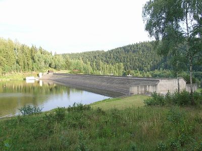
Žlutice Reservoir is a large water body on the Střela river near the town of Žlutice, created to store water for the region since the late 1960s. The water extends for several kilometers with gently sloping banks surrounded by fields and forests, held back by a 230-meter stone dam with an intake tower.

The reservoir was constructed between 1965 and 1968 to store water, control flooding, and later generate electricity through a power plant installed in the late 1990s. The project flooded two small settlements, Mlyňany and Dolánky, along with historic roads and mills that once served the community.

The reservoir is woven into local life, where fishermen and families gather for traditional activities like angling and weekend outings. The water serves as a social gathering point, especially during summer months when locals picnic and swim in designated areas.

The site is easily accessible by road and rail with parking available near the water and paths suitable for walking or cycling. Visitors can come year-round, though summer offers the best conditions for swimming and fishing in designated areas.

A small power plant with two turbines generates roughly 900 megawatt-hours of electricity annually, demonstrating how the water serves local energy needs. Water flow can increase dramatically during heavy storms, and the dam's wide spillway is designed to handle over 200 cubic meters per second without risk of overflow.

The community of curious travelers

AroundUs brings together thousands of curated places, local tips, and hidden gems, enriched daily by 60,000 contributors worldwide.

Start exploring
Location
Inception
1965
Elevation above the sea
507.95 m
GPS coordinates
50.08810,13.12810
Latest update
February 9, 2026 08:22
Around this place
Church of Saint Nicholas
Czech Republic

Church of Saint Nicholas

1.6 km
Sousoší Nejsvětější Trojice ve Verušicích
Czech Republic

Sousoší Nejsvětější Trojice ve Verušicích

986 m
Socha Panny Marie
Czech Republic

Socha Panny Marie

2.3 km
Sousoší Nejsvětější Trojice
Czech Republic

Sousoší Nejsvětější Trojice

988 m
Bílá muka
Czech Republic

Bílá muka

2.1 km
Chapel of Saint John of Nepomuk
Czech Republic

Chapel of Saint John of Nepomuk

1.6 km
Kunzova muka
Czech Republic

Kunzova muka

2.1 km
Chapel
Czech Republic

Chapel

948 m
Tuchtova kaple ve Verušicích
Czech Republic

Tuchtova kaple ve Verušicích

1.1 km
Kaple Panny Marie jižně od Žlutic
Czech Republic

Kaple Panny Marie jižně od Žlutic

1.6 km
Lienerthův kříž ve Skokách
Czech Republic

Lienerthův kříž ve Skokách

2.3 km
Kříž při bývalé cestě do Verušic východně od Skoků
Czech Republic

Kříž při bývalé cestě do Verušic východně od Skoků

2 km
Mischkova kaple mezi Verušicemi a Žluticemi
Czech Republic

Mischkova kaple mezi Verušicemi a Žluticemi

1.9 km
Černý kříž u Verušic
Czech Republic

Černý kříž u Verušic

1.5 km
Kaplička svatého Jakuba Většího jižně od Verušic
Czech Republic

Kaplička svatého Jakuba Většího jižně od Verušic

643 m
Kříž na jižním okraji Verušic
Czech Republic

Kříž na jižním okraji Verušic

867 m
Kříž na okraji Mostce
Czech Republic

Kříž na okraji Mostce

2.1 km
Kříž u stodoly usedlosti čp. 11 v Semtěši
Czech Republic

Kříž u stodoly usedlosti čp. 11 v Semtěši

2.2 km
Kunzova muka severozápadně od Žlutic
Czech Republic

Kunzova muka severozápadně od Žlutic

2.1 km
Kaplička jihovýchodně Skoků
Czech Republic

Kaplička jihovýchodně Skoků

2.1 km
Kaple svatého Antonína Poustevníka v Semtěši
Czech Republic

Kaple svatého Antonína Poustevníka v Semtěši

2.2 km
Kaple v Semtěši
Czech Republic

Kaple v Semtěši

2.2 km
Siemerův kříž u Verušic
Czech Republic

Siemerův kříž u Verušic

1.2 km
Pomník Antona Härtla mezi Mostcem a Štědrou
Czech Republic

Pomník Antona Härtla mezi Mostcem a Štědrou

2.3 km
Železný kříž nad Rábovým mlýnem v Mlyňanech
Czech Republic

Železný kříž nad Rábovým mlýnem v Mlyňanech

2 km
Neumannův kříž mezi Verušicemi a Žluticemi
Czech Republic

Neumannův kříž mezi Verušicemi a Žluticemi

1.8 km
Kaple svatého Antonína v Mostci
Czech Republic

Kaple svatého Antonína v Mostci

2.1 km
Spinkův kříž u Žlutic
Czech Republic

Spinkův kříž u Žlutic

2.1 km
Show the full map
Reviews
Share your experience

No review yet

Discussions
Start a discussion...

No discussion yet

« Žlutice Reservoir - reservoir in Žlutice, Czech Republic » is provided by Around Us (aroundus.com). Images and texts are derived from Wikimedia project under a Creative Commons license. You are allowed to copy, distribute, and modify copies of this page, under the conditions set by the license, as long as this note is clearly visible.

Discover hidden gems everywhere you go!

From secret cafés to breathtaking viewpoints, skip the crowded tourist spots and find places that match your style. Our app makes it easy with voice search, smart filtering, route optimization, and insider tips from travelers worldwide. Download now for the complete mobile experience.

Around Us App Screenshot

A unique approach to discovering new places

Le Figaro

All the places worth exploring

France Info

A tailor-made excursion in just a few clicks

20 Minutes

Around Us
Travel Guide & Maps
Download

Send to your phone

QR Code
1

Open the camera app on your mobile.

2

Point at the QR code with your camera. A notification will appear.

3

Tap the notification to open the link.