Enable Location

We need your location to show you interesting places around you

Discover nearby places

Find interesting locations and hidden gems around you

Precise directions

Get accurate directions and distances to places

Your location is never shared with other users. It's only used when you tap the location button.

Vojslavický most

Log in to your account

Start exploring — it's free

Trusted by 62,414 travelers worldwide

Continue with Google
Continue with Apple
or

We will send you a code to connect

By continuing, you accept our Terms and Conditions and our Privacy Policy

Check your inbox

We've sent a pincode in your inbox. Please enter the code below.

Vojslavický most

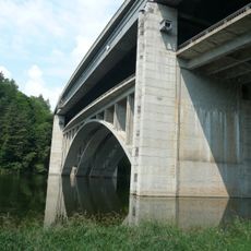
Vojslavický most, Highway bridge in Vojslavice, Czech Republic.

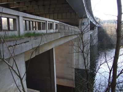
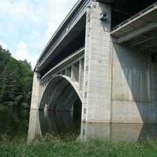
Vojslavický most is a dual bridge structure spanning the Желivka River valley with two parallel constructions at different elevations. The upper section carries the D1 motorway, while the lower bridge serves local traffic on road III/13036 connecting nearby settlements.

Planning for a bridge at this location began in 1939 as part of a national highway system, though World War II halted construction until after 1945. The project resumed in the postwar period to complete the connection.

The bridge received designation as a cultural monument of the Czech Republic, representing the evolution of transportation infrastructure in the region.

The bridge is accessible year-round, with the lower roadway suitable for standard passenger vehicles. Parking is available in the nearby towns of Vojslavice and Hořice for visitors interested in viewing the structure.

The two bridge structures were engineered at different vertical elevations to meet modern slope requirements for the motorway. This technical solution allowed both traffic systems to coexist at the same location without interfering with each other.

The community of curious travelers

AroundUs brings together thousands of curated places, local tips, and hidden gems, enriched daily by 60,000 contributors worldwide.

Start exploring
Location
Location
Location
Inception
20 century
GPS coordinates
49.59600,15.20720
Latest update
December 9, 2025 18:40
Around this place
Church of the Assumption of the Virgin Mary in Vojslavice
Czech Republic

Church of the Assumption of the Virgin Mary in Vojslavice

1.6 km
Memorial of anticommunism in Blažejovice
Czech Republic

Memorial of anticommunism in Blažejovice

2.7 km
Horní most
Czech Republic

Horní most

17 m
Pamětní deska zakládajícím členům sboru dobrovolných hasičů v Píšti
Czech Republic

Pamětní deska zakládajícím členům sboru dobrovolných hasičů v Píšti

702 m
Pamětní kámen v Hrozněticích
Czech Republic

Pamětní kámen v Hrozněticích

1 km
Dolní obloukový dálniční most u Vojslavic
Czech Republic

Dolní obloukový dálniční most u Vojslavic

12 m
Chapel in Píšť
Czech Republic

Chapel in Píšť

710 m
Kříž u kostela sv. Lucie v Ježově
Czech Republic

Kříž u kostela sv. Lucie v Ježově

2.7 km
Kříž u kaple v Píšti
Czech Republic

Kříž u kaple v Píšti

707 m
Kaple u hasičské zbrojnice v Hořicích
Czech Republic

Kaple u hasičské zbrojnice v Hořicích

1.6 km
Kříž u kaple v Hrozněticích
Czech Republic

Kříž u kaple v Hrozněticích

1 km
Kříž u silnice před Ježovem
Czech Republic

Kříž u silnice před Ježovem

2.3 km
Kaplička a boží muka na křižovatce silnic západně od Hořic u Humpolce
Czech Republic

Kaplička a boží muka na křižovatce silnic západně od Hořic u Humpolce

1.9 km
Kříž u silnice mezi Hořicemi a Píští
Czech Republic

Kříž u silnice mezi Hořicemi a Píští

1.1 km
Kříž u kaple v Hořicích
Czech Republic

Kříž u kaple v Hořicích

1.6 km
Kříž na rozcestí severovýchodně od Píště
Czech Republic

Kříž na rozcestí severovýchodně od Píště

909 m
Kříž na západním okraji Hořic
Czech Republic

Kříž na západním okraji Hořic

1.8 km
Kříž v Rachyni
Czech Republic

Kříž v Rachyni

1.8 km
Kříž v poli jižně od samoty Bukovina
Czech Republic

Kříž v poli jižně od samoty Bukovina

1 km
Chapel in Vranice
Czech Republic

Chapel in Vranice

1.3 km
Kříž u silnice mezi Hořicemi a Hrozněticemi
Czech Republic

Kříž u silnice mezi Hořicemi a Hrozněticemi

837 m
Kříž u cesty jihovýchodně od Hořic
Czech Republic

Kříž u cesty jihovýchodně od Hořic

1.2 km
Kříž v Děkančicích
Czech Republic

Kříž v Děkančicích

1 km
Kaple v Hořicích
Czech Republic

Kaple v Hořicích

1.6 km
Chapel in Děkančice
Czech Republic

Chapel in Děkančice

1 km
Bell tower
Czech Republic

Bell tower

2.8 km
Zvonička v Hrozněticích
Czech Republic

Zvonička v Hrozněticích

1 km
Kříž u domu čp. 10 v Děkančicích
Czech Republic

Kříž u domu čp. 10 v Děkančicích

1.2 km
Show the full map
« Vojslavický most - Highway bridge in Vojslavice, Czech Republic » is provided by Around Us (aroundus.com). Images and texts are derived from Wikimedia project under a Creative Commons license. You are allowed to copy, distribute, and modify copies of this page, under the conditions set by the license, as long as this note is clearly visible.

Discover hidden gems everywhere you go!

From secret cafés to breathtaking viewpoints, skip the crowded tourist spots and find places that match your style. Our app makes it easy with voice search, smart filtering, route optimization, and insider tips from travelers worldwide. Download now for the complete mobile experience.

Around Us App Screenshot

A unique approach to discovering new places

Le Figaro

All the places worth exploring

France Info

A tailor-made excursion in just a few clicks

20 Minutes

Around Us
Travel Guide & Maps
Download

Send to your phone

QR Code
1

Open the camera app on your mobile.

2

Point at the QR code with your camera. A notification will appear.

3

Tap the notification to open the link.