Enable Location

We need your location to show you interesting places around you

Discover nearby places

Find interesting locations and hidden gems around you

Precise directions

Get accurate directions and distances to places

Your location is never shared with other users. It's only used when you tap the location button.

Kamenný pastýř

Log in to your account

Start exploring — it's free

Trusted by 62,922 travelers worldwide

Continue with Google
Continue with Apple
or

We will send you a code to connect

By continuing, you accept our Terms and Conditions and our Privacy Policy

Check your inbox

We've sent a pincode in your inbox. Please enter the code below.

Kamenný pastýř
Discussion Reviews 1 Photos
6.1k Popularity

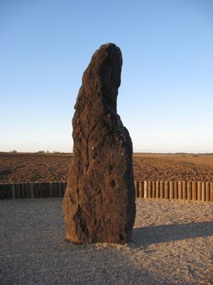
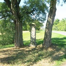
Kamenný pastýř, Prehistoric menhir in Klobuky, Czech Republic.

Kamenný pastýř is an upright stone monument of dark ferruginous sandstone located near Klobuky. The structure stands roughly 3.5 meters tall and weighs several tons, representing one of the larger prehistoric stones in the region.

The stone first appeared in military maps during the 18th century. Nineteenth-century researchers examined it and confirmed that it had been deliberately placed by human hands.

The stone holds a place in the local identity of Klobuky, where its name references a shepherd who vanished. Stories passed down through generations describe strange occurrences connected to the menhir on certain nights.

The menhir stands roughly 100 meters east of the road connecting Klobuky and Telce, with free access available throughout the year. The location is straightforward to reach and imposes no entry restrictions or time constraints on visitors.

Measurements conducted around the summer solstice have detected geomagnetic field anomalies in the immediate vicinity of the stone. This phenomenon remains relatively overlooked when compared to other aspects of the site.

The community of curious travelers

AroundUs brings together thousands of curated places, local tips, and hidden gems, enriched daily by 60,000 contributors worldwide.

Start exploring
GPS coordinates
50.30128,13.98448
Latest update
December 8, 2025 19:45
Around this place
Church of Saint Nicholas
Czech Republic

Church of Saint Nicholas

843 m
Bohouškova skalka
Czech Republic

Bohouškova skalka

1.5 km
Church of Saint Lawrence (Klobuky)
Czech Republic

Church of Saint Lawrence (Klobuky)

1 km
Pomník k 100. výročí osvobozenecké války proti Napoleonovi
Czech Republic

Pomník k 100. výročí osvobozenecké války proti Napoleonovi

3.2 km
Propustek pod železniční tratí mezi Klobuky a Vrbičany
Czech Republic

Propustek pod železniční tratí mezi Klobuky a Vrbičany

826 m
Pomník padlým ve Vrbičanech
Czech Republic

Pomník padlým ve Vrbičanech

1.4 km
Socha svatého Jana Nepomuckého
Czech Republic

Socha svatého Jana Nepomuckého

2.1 km
Wayside cross and bell tower in Kobylníky
Czech Republic

Wayside cross and bell tower in Kobylníky

1.9 km
Pomník padlým v 1. světové válce v Kobylníkách
Czech Republic

Pomník padlým v 1. světové válce v Kobylníkách

1.9 km
Dub letní
Czech Republic

Dub letní

1 km
Kaple a kříž
Czech Republic

Kaple a kříž

1.1 km
Kaplička na severním okraji Klobuk
Czech Republic

Kaplička na severním okraji Klobuk

619 m
Kříž naproti domu 44 ve Vrbičanech
Czech Republic

Kříž naproti domu 44 ve Vrbičanech

1.3 km
Pamětní desky Janů Malypetrů na domě 11 v Klobukách
Czech Republic

Pamětní desky Janů Malypetrů na domě 11 v Klobukách

971 m
Chapel of Saint John of Nepomuk
Czech Republic

Chapel of Saint John of Nepomuk

2.2 km
Kříž na rozcestí ulic Nádražní a Na Karlově v Telcích
Czech Republic

Kříž na rozcestí ulic Nádražní a Na Karlově v Telcích

1.7 km
Kříž v ulici Na Skala v Telcích
Czech Republic

Kříž v ulici Na Skala v Telcích

1.5 km
Kříž v ulici Rudé armády v Telcích
Czech Republic

Kříž v ulici Rudé armády v Telcích

1.4 km
Pamětní deska Václava Konopáska na škole v Klobukách
Czech Republic

Pamětní deska Václava Konopáska na škole v Klobukách

871 m
Kříž u kaple ve Vrbičanech
Czech Republic

Kříž u kaple ve Vrbičanech

1.1 km
Pamětní deska Jindřicha Šimona Baara na kostele v Klobukách
Czech Republic

Pamětní deska Jindřicha Šimona Baara na kostele v Klobukách

1 km
Kříž u pomníku v Kobylníkách
Czech Republic

Kříž u pomníku v Kobylníkách

1.9 km
Pomník padlým na návsi v Úhercích
Czech Republic

Pomník padlým na návsi v Úhercích

2.5 km
Pamětní deska Karla Tomana na domě 8 v Kokovicích
Czech Republic

Pamětní deska Karla Tomana na domě 8 v Kokovicích

1.6 km
Kaple Neposkvrněného Početí Panny Marie v Úhercích
Czech Republic

Kaple Neposkvrněného Početí Panny Marie v Úhercích

2.5 km
Kaplička na návsi v Kokovicích
Czech Republic

Kaplička na návsi v Kokovicích

1.6 km
Pomník padlým na návsi v Klobukách
Czech Republic

Pomník padlým na návsi v Klobukách

816 m
Kašna na návsi v Klobukách
Czech Republic

Kašna na návsi v Klobukách

816 m
Show the full map
Reviews
Share your experience

No review yet

Discussions
Start a discussion...

No discussion yet

« Kamenný pastýř - Prehistoric menhir in Klobuky, Czech Republic » is provided by Around Us (aroundus.com). Images and texts are derived from Wikimedia project under a Creative Commons license. You are allowed to copy, distribute, and modify copies of this page, under the conditions set by the license, as long as this note is clearly visible.

Discover hidden gems everywhere you go!

From secret cafés to breathtaking viewpoints, skip the crowded tourist spots and find places that match your style. Our app makes it easy with voice search, smart filtering, route optimization, and insider tips from travelers worldwide. Download now for the complete mobile experience.

Around Us App Screenshot

A unique approach to discovering new places

Le Figaro

All the places worth exploring

France Info

A tailor-made excursion in just a few clicks

20 Minutes

Around Us
Travel Guide & Maps
Download

Send to your phone

QR Code
1

Open the camera app on your mobile.

2

Point at the QR code with your camera. A notification will appear.

3

Tap the notification to open the link.