Enable Location

We need your location to show you interesting places around you

Discover nearby places

Find interesting locations and hidden gems around you

Precise directions

Get accurate directions and distances to places

Your location is never shared with other users. It's only used when you tap the location button.

Koh-i-noor II mine

Log in to your account

Start exploring — it's free

Trusted by 61,918 travelers worldwide

Continue with Google
Continue with Apple
or

We will send you a code to connect

By continuing, you accept our Terms and Conditions and our Privacy Policy

Check your inbox

We've sent a pincode in your inbox. Please enter the code below.

Koh-i-noor II mine

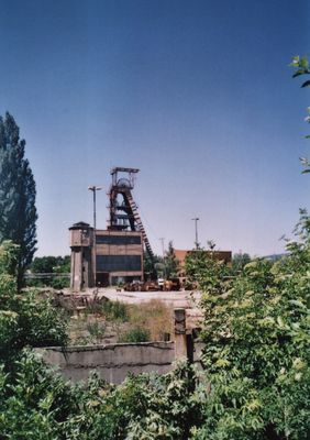
Koh-i-noor II mine, Brown coal mine in Mariánské Radčice, Czech Republic

Koh-i-noor II is a brown coal mine in Mariánské Radčice that extracted residual coal reserves from the side slopes of the nearby ČSA Mine. The operation is located in northern Bohemia within a region historically defined by coal extraction.

The mine started operations on February 1, 2000, specifically designed to manage the closure of the original Kohinoor site. It represented one of the final phases of deep brown coal mining before the sector ended in the country.

This place represents coal mining heritage in the region and shows how deeply this work shaped people's lives locally. The landscape itself tells the story of decades of industrial activity and the changes the area has experienced.

The site is a former mining operation without regular visitor access, and viewing requires special permission from local authorities. The area remains an industrial site with restrictions for the general public.

The mine was specifically created to enable a gradual closure rather than an abrupt end to coal extraction. This made it a transitional example of how to manage facility shutdowns in the European mining industry.

The community of curious travelers

AroundUs brings together thousands of curated places, local tips, and hidden gems, enriched daily by 60,000 contributors worldwide.

Start exploring
GPS coordinates
50.57946,13.65451
Latest update
December 14, 2025 09:46
Around this place
Church of Our Lady of Sorrows (Mariánské Radčice)
Czech Republic

Church of Our Lady of Sorrows (Mariánské Radčice)

933 m
Church of the Sacred Heart in Lom
Czech Republic

Church of the Sacred Heart in Lom

1.6 km
Niche chapels from Libkovice in Vtelno
Czech Republic

Niche chapels from Libkovice in Vtelno

1.7 km
Chapel of Saint Anthony of Padua (Louka u Litvínova)
Czech Republic

Chapel of Saint Anthony of Padua (Louka u Litvínova)

1.4 km
Pomník Francisca Ferrera u obecního úřadu v Lomu u Mostu
Czech Republic

Pomník Francisca Ferrera u obecního úřadu v Lomu u Mostu

1.5 km
Pomník osvobození v Sokolovské ulici v Louce u Litvínova
Czech Republic

Pomník osvobození v Sokolovské ulici v Louce u Litvínova

1.7 km
Statue of Saint Lawrence in Mariánské Radčice
Czech Republic

Statue of Saint Lawrence in Mariánské Radčice

1 km
Statue of Felix of Cantalica in Mariánské Radčice
Czech Republic

Statue of Felix of Cantalica in Mariánské Radčice

993 m
Pomník americkému letci
Czech Republic

Pomník americkému letci

1.5 km
Statue of John of Nepomuk in Mariánské Radčice
Czech Republic

Statue of John of Nepomuk in Mariánské Radčice

989 m
Socha Panny Marie
Czech Republic

Socha Panny Marie

978 m
Sokl kříže
Czech Republic

Sokl kříže

972 m
Pomník obětem koncentračních táborů
Czech Republic

Pomník obětem koncentračních táborů

1.6 km
Dva smírčí kříže
Czech Republic

Dva smírčí kříže

1 km
Sokl s reliéfem
Czech Republic

Sokl s reliéfem

1.5 km
Pomník obětem neštěstí na dole Pluto II v Louce u Litvínova
Czech Republic

Pomník obětem neštěstí na dole Pluto II v Louce u Litvínova

1.3 km
Morový sloupek
Czech Republic

Morový sloupek

1.5 km
Holy Trinity column
Czech Republic

Holy Trinity column

977 m
Column shrine at the stream
Czech Republic

Column shrine at the stream

1 km
Boží muka
Czech Republic

Boží muka

1 km
Dům čp. 1
Czech Republic

Dům čp. 1

948 m
Dům čp. 364
Czech Republic

Dům čp. 364

1.7 km
Dům čp. 23
Czech Republic

Dům čp. 23

1.7 km
Smírčí kříž
Czech Republic

Smírčí kříž

1.5 km
Dělnický dům
Czech Republic

Dělnický dům

1.6 km
Kříž u kaple v Louce u Litvínova
Czech Republic

Kříž u kaple v Louce u Litvínova

1.4 km
Pomník padlých v Mariánských Radčicích
Czech Republic

Pomník padlých v Mariánských Radčicích

498 m
Kříž u potoka za kaplí v Louce u Litvínova
Czech Republic

Kříž u potoka za kaplí v Louce u Litvínova

1.3 km
Show the full map
« Koh-i-noor II mine - Brown coal mine in Mariánské Radčice, Czech Republic » is provided by Around Us (aroundus.com). Images and texts are derived from Wikimedia project under a Creative Commons license. You are allowed to copy, distribute, and modify copies of this page, under the conditions set by the license, as long as this note is clearly visible.

Discover hidden gems everywhere you go!

From secret cafés to breathtaking viewpoints, skip the crowded tourist spots and find places that match your style. Our app makes it easy with voice search, smart filtering, route optimization, and insider tips from travelers worldwide. Download now for the complete mobile experience.

Around Us App Screenshot

A unique approach to discovering new places

Le Figaro

All the places worth exploring

France Info

A tailor-made excursion in just a few clicks

20 Minutes

Around Us
Travel Guide & Maps
Download

Send to your phone

QR Code
1

Open the camera app on your mobile.

2

Point at the QR code with your camera. A notification will appear.

3

Tap the notification to open the link.