Enable Location

We need your location to show you interesting places around you

Discover nearby places

Find interesting locations and hidden gems around you

Precise directions

Get accurate directions and distances to places

Your location is never shared with other users. It's only used when you tap the location button.

Inundation bridge over the Vítek pond

Log in to your account

Start exploring — it's free

Trusted by 62,539 travelers worldwide

Continue with Google
Continue with Apple
or

We will send you a code to connect

By continuing, you accept our Terms and Conditions and our Privacy Policy

Check your inbox

We've sent a pincode in your inbox. Please enter the code below.

Inundation bridge over the Vítek pond

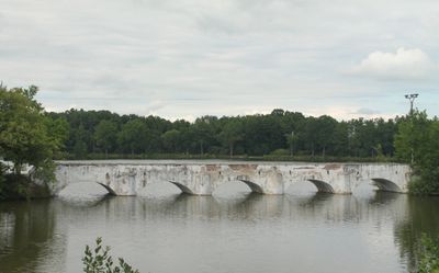
Inundation bridge over the Vítek pond, Technical monument at Vítek pond in Stará Hlína, Czech Republic.

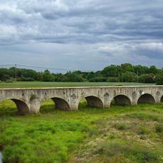
The inundation bridge over the Vítek pond is a structure built from rubble stone that crosses the water body in Stará Hlína. It serves as an important component of the local water management infrastructure.

The bridge was constructed in 1781 by Joseph Rosenauer as part of major infrastructure development in the South Bohemian region. This period saw extensive water management projects undertaken across the area.

The bridge holds official recognition as a cultural monument of the Czech Republic under the identification number 40710/3-2196.

The structure is located in Stará Hlína and remains accessible for visitors interested in historical water management works. Visiting during normal or low water levels offers the best view of the entire construction.

The structure features specific engineering characteristics that allow it to function during flood periods while maintaining water flow control. This design makes it a remarkable example of practical 18th-century water management solutions.

The community of curious travelers

AroundUs brings together thousands of curated places, local tips, and hidden gems, enriched daily by 60,000 contributors worldwide.

Start exploring
Location
Inception
1781
Architects
Joseph Rosenauer
Official opening
1781
Made from material
rubble
GPS coordinates
49.03257,14.80606
Latest update
December 14, 2025 13:08
Around this place
Třeboňské seníky
Czech Republic

Třeboňské seníky

3.1 km
Inundation bridge over the Lužnice in Stará Hlína
Czech Republic

Inundation bridge over the Lužnice in Stará Hlína

800 m
Jewish cemetery in Třeboň
Czech Republic

Jewish cemetery in Třeboň

1.5 km
Výtopa Rožmberka
Czech Republic

Výtopa Rožmberka

1.3 km
Tři bratři
Czech Republic

Tři bratři

1.9 km
Jindrův mlýn
Czech Republic

Jindrův mlýn

2.6 km
Rybníky u Vitmanova
Czech Republic

Rybníky u Vitmanova

2.7 km
Kaple svatého Václava a Panny Marie (Stará Hlína)
Czech Republic

Kaple svatého Václava a Panny Marie (Stará Hlína)

962 m
Monument to 1945 liberation in Holičky
Czech Republic

Monument to 1945 liberation in Holičky

2.7 km
Odpočívající Kristus
Czech Republic

Odpočívající Kristus

2.7 km
Chapel of Saint Vitus (Třeboň)
Czech Republic

Chapel of Saint Vitus (Třeboň)

2.3 km
Dub u Nového Vdovce
Czech Republic

Dub u Nového Vdovce

2 km
Water tower in Třeboň
Czech Republic

Water tower in Třeboň

2.7 km
Hadí křížek
Czech Republic

Hadí křížek

2 km
Monument to Jakub Krčín near Smitka
Czech Republic

Monument to Jakub Krčín near Smitka

2.7 km
Chapel of Saints Peter and Paul
Czech Republic

Chapel of Saints Peter and Paul

2.7 km
Chapel of Saint John of Nepomuk in Třeboň, Pod Kopečkem
Czech Republic

Chapel of Saint John of Nepomuk in Třeboň, Pod Kopečkem

2.9 km
Socha Budhy v Zahradě soucitu v osadě Na Kopečku
Czech Republic

Socha Budhy v Zahradě soucitu v osadě Na Kopečku

2.7 km
Památné stromořadí u Rožmberka
Czech Republic

Památné stromořadí u Rožmberka

3 km
Dub u Starého Vdovce 2
Czech Republic

Dub u Starého Vdovce 2

1.9 km
Kříž u čp. 33
Czech Republic

Kříž u čp. 33

949 m
Kamenný milník na rozcestí v osadě Na Kopečku
Czech Republic

Kamenný milník na rozcestí v osadě Na Kopečku

2.8 km
Dva kříže na rozcestí k Stupskému rybníku východně od Třeboně
Czech Republic

Dva kříže na rozcestí k Stupskému rybníku východně od Třeboně

2.5 km
Kříž u Jindrova mlýna východně od Třeboně
Czech Republic

Kříž u Jindrova mlýna východně od Třeboně

2.6 km
Kříž u severního předmostí mostu přes Lužnici
Czech Republic

Kříž u severního předmostí mostu přes Lužnici

843 m
Kříž u čp. 62
Czech Republic

Kříž u čp. 62

273 m
Kříž na návsi
Czech Republic

Kříž na návsi

707 m
Kříž u kaple  v osadě Na Kopečku
Czech Republic

Kříž u kaple v osadě Na Kopečku

2.9 km
Show the full map
« Inundation bridge over the Vítek pond - Technical monument at Vítek pond in Stará Hlína, Czech Republic » is provided by Around Us (aroundus.com). Images and texts are derived from Wikimedia project under a Creative Commons license. You are allowed to copy, distribute, and modify copies of this page, under the conditions set by the license, as long as this note is clearly visible.

Discover hidden gems everywhere you go!

From secret cafés to breathtaking viewpoints, skip the crowded tourist spots and find places that match your style. Our app makes it easy with voice search, smart filtering, route optimization, and insider tips from travelers worldwide. Download now for the complete mobile experience.

Around Us App Screenshot

A unique approach to discovering new places

Le Figaro

All the places worth exploring

France Info

A tailor-made excursion in just a few clicks

20 Minutes

Around Us
Travel Guide & Maps
Download

Send to your phone

QR Code
1

Open the camera app on your mobile.

2

Point at the QR code with your camera. A notification will appear.

3

Tap the notification to open the link.