Enable Location

We need your location to show you interesting places around you

Discover nearby places

Find interesting locations and hidden gems around you

Precise directions

Get accurate directions and distances to places

Your location is never shared with other users. It's only used when you tap the location button.

Nejsevernější bod Česka

Log in to your account

Start exploring — it's free

Trusted by 62,214 travelers worldwide

Continue with Google
Continue with Apple
or

We will send you a code to connect

By continuing, you accept our Terms and Conditions and our Privacy Policy

Check your inbox

We've sent a pincode in your inbox. Please enter the code below.

Nejsevernější bod Česka

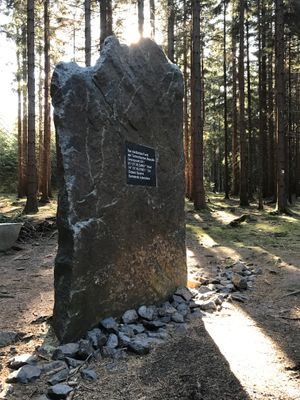
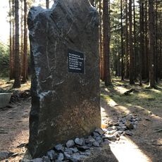
Nejsevernější bod Česka, Geographic marker in Šluknov, Czech Republic

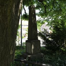
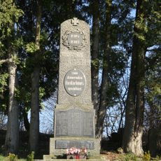
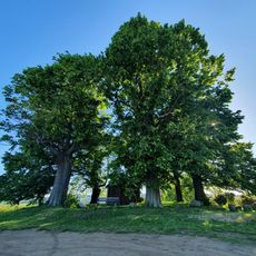
The northernmost point of the Czech Republic is marked by a memorial stone located near Šluknov at the border with Germany. The monument is a simple but significant marker at this geographical extremity.

The memorial stone was officially dedicated in 2013 as part of a program to mark important geographical points across the country. Directional signs had been placed in the area earlier to guide people to the exact location.

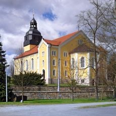
The site marks a physical boundary between two nations and shows how people recognize geographical extremities in their homeland. Places like this often carry symbolic meaning for how communities understand their national borders.

You can reach the location by hiking or by car, with signs placed to guide you to the spot. Access is straightforward once you follow the directional markers.

The location sits at a place where the borders of neighboring countries come very close to one another. This makes it a point of geographic intrigue for visitors interested in how national boundaries actually align on the ground.

The community of curious travelers

AroundUs brings together thousands of curated places, local tips, and hidden gems, enriched daily by 60,000 contributors worldwide.

Start exploring
GPS coordinates
51.05569,14.31562
Latest update
December 9, 2025 18:45
Around this place
Kirche Steinigtwolmsdorf
Germany

Kirche Steinigtwolmsdorf

2.3 km
Hutberg
Germany

Hutberg

2 km
Pomník nejsevernějšího bodu ČR severně od Severní
Czech Republic

Pomník nejsevernějšího bodu ČR severně od Severní

9 m
Umlaufende Einfriedungsmauer (Einzeldenkmal zu ID-Nr. 09303909) Am Markt
Germany

Umlaufende Einfriedungsmauer (Einzeldenkmal zu ID-Nr. 09303909) Am Markt

2.3 km
Denkmale für die Gefallenen des Deutsch-Französischen und des Ersten Weltkrieges (Einzeldenkmal zu ID-Nr. 09303909) Am Markt
Germany

Denkmale für die Gefallenen des Deutsch-Französischen und des Ersten Weltkrieges (Einzeldenkmal zu ID-Nr. 09303909) Am Markt

2.3 km
Denkmal für die Gefallenen des Ersten Weltkrieges in Hilgersdorf
Czech Republic

Denkmal für die Gefallenen des Ersten Weltkrieges in Hilgersdorf

2.2 km
Wesenitzmühle
Germany

Wesenitzmühle

1.9 km
Sieben Linden
Germany

Sieben Linden

1.5 km
Kirche und Kirchhof Steinigtwolmsdorf mit Friedhofserweiterung (Sachgesamtheit) Am Markt
Germany

Kirche und Kirchhof Steinigtwolmsdorf mit Friedhofserweiterung (Sachgesamtheit) Am Markt

2.3 km
Rittergut Steinigtwolmsdorf
Germany

Rittergut Steinigtwolmsdorf

2.3 km
Grenzstraße 50
Germany

Grenzstraße 50

2 km
Mittelstraße 32 Steinigtwolmsdorf
Germany

Mittelstraße 32 Steinigtwolmsdorf

2.5 km
Dresdener Straße 44
Germany

Dresdener Straße 44

2.4 km
Grenzstraße 40
Germany

Grenzstraße 40

2 km
Sachgesamtheit Hohwaldklinik mit folgenden Einzeldenkmalen: Hauptklinikgebäude, Wäschereigebäude mit Heizhaus, Küchengebäude und Speisesaal - davor Freitreppenanlage, Werkstattgebäude (ohne verglasten Verandaanbau, heute Gästehaus), zwei weite
Germany

Sachgesamtheit Hohwaldklinik mit folgenden Einzeldenkmalen: Hauptklinikgebäude, Wäschereigebäude mit Heizhaus, Küchengebäude und Speisesaal - davor Freitreppenanlage, Werkstattgebäude (ohne verglasten Verandaanbau, heute Gästehaus), zwei weite

1.9 km
Grenzstraße 11
Germany

Grenzstraße 11

2.1 km
Andreas Thomas Brettmühle
Germany

Andreas Thomas Brettmühle

2.8 km
Wohnstallhaus Mittelstraße 20
Germany

Wohnstallhaus Mittelstraße 20

2.5 km
Wohnhaus (Umgebinde) mit Vorlaube Mittelstraße 16
Germany

Wohnhaus (Umgebinde) mit Vorlaube Mittelstraße 16

2.5 km
Wohnhaus mit Scheunenanbau Talweg 1
Germany

Wohnhaus mit Scheunenanbau Talweg 1

2.5 km
Gasthof Talweg 2
Germany

Gasthof Talweg 2

2.5 km
Dresdener Straße 55
Germany

Dresdener Straße 55

2.5 km
Grenzstraße 10
Germany

Grenzstraße 10

2.2 km
Grenzstraße 38
Germany

Grenzstraße 38

2 km
Wohnhaus (Umgebinde) Mittelstraße 23
Germany

Wohnhaus (Umgebinde) Mittelstraße 23

2.5 km
Dresdener Straße 21
Germany

Dresdener Straße 21

2.8 km
Gasthof „Waldschlößchen“ mit zum Teil originaler Ausstattung Karl-Berger-Straße 17
Germany

Gasthof „Waldschlößchen“ mit zum Teil originaler Ausstattung Karl-Berger-Straße 17

2.8 km
Wohnhaus (Umgebinde) Mittelstraße 17, 19
Germany

Wohnhaus (Umgebinde) Mittelstraße 17, 19

2.5 km
Show the full map
« Nejsevernější bod Česka - Geographic marker in Šluknov, Czech Republic » is provided by Around Us (aroundus.com). Images and texts are derived from Wikimedia project under a Creative Commons license. You are allowed to copy, distribute, and modify copies of this page, under the conditions set by the license, as long as this note is clearly visible.

Discover hidden gems everywhere you go!

From secret cafés to breathtaking viewpoints, skip the crowded tourist spots and find places that match your style. Our app makes it easy with voice search, smart filtering, route optimization, and insider tips from travelers worldwide. Download now for the complete mobile experience.

Around Us App Screenshot

A unique approach to discovering new places

Le Figaro

All the places worth exploring

France Info

A tailor-made excursion in just a few clicks

20 Minutes

Around Us
Travel Guide & Maps
Download

Send to your phone

QR Code
1

Open the camera app on your mobile.

2

Point at the QR code with your camera. A notification will appear.

3

Tap the notification to open the link.