Enable Location

We need your location to show you interesting places around you

Discover nearby places

Find interesting locations and hidden gems around you

Precise directions

Get accurate directions and distances to places

Your location is never shared with other users. It's only used when you tap the location button.

Viadukt Pernink

Log in to your account

Start exploring — it's free

Trusted by 62,399 travelers worldwide

Continue with Google
Continue with Apple
or

We will send you a code to connect

By continuing, you accept our Terms and Conditions and our Privacy Policy

Check your inbox

We've sent a pincode in your inbox. Please enter the code below.

Viadukt Pernink

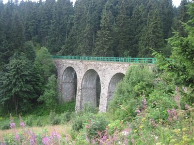
Viadukt Pernink, Railway bridge in Pernink, Czech Republic

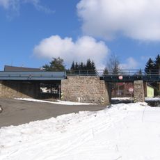
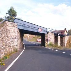
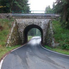
Viaduct Pernink is a railway bridge that crosses a valley using six stone arches built into the landscape. The structure carries trains on the route between Karlovy Vary and Johanngeorgenstadt, passing through the surrounding mountain terrain.

The bridge was completed in 1899 and served as a vital connection between Czech lands and Saxony via the railway line. Its construction came during a period of growing industrial activity in the mountain region.

The viaduct stands near Pernink, a former mining town founded in 1532 by Saxon miners, reflecting the industrial development of the Ore Mountains region.

The viaduct can be viewed from several points along the surrounding slopes and accessible paths in the area. Walking trails through the valley and hillsides offer the best vantage points for seeing the full structure.

The stone structure sits at an elevation of around 900 meters, making it one of the highest railway viaducts in the country. This mountain location showcases impressive engineering work in challenging terrain.

The community of curious travelers

AroundUs brings together thousands of curated places, local tips, and hidden gems, enriched daily by 60,000 contributors worldwide.

Start exploring
Location
Inception
1899
Part of
Karlovy Vary–Johanngeorgenstadt railway
GPS coordinates
50.36389,12.77389
Latest update
December 14, 2025 12:23
Around this place
Pernink
Czech Republic

Pernink

1.8 km
Oceán
Czech Republic

Oceán

2.4 km
Saint Cross chapel in Horní Blatná
Czech Republic

Saint Cross chapel in Horní Blatná

2.8 km
Jilm v Perninku
Czech Republic

Jilm v Perninku

792 m
Holy Trinity church in Pernink
Czech Republic

Holy Trinity church in Pernink

793 m
Vetešníkův jasan v Perninku
Czech Republic

Vetešníkův jasan v Perninku

717 m
Železniční most přes Hamerskou ulici a Blatenský příkop v Horní Blatné
Czech Republic

Železniční most přes Hamerskou ulici a Blatenský příkop v Horní Blatné

2.8 km
Železniční most přes Majakovského ulici v Horní Blatné
Czech Republic

Železniční most přes Majakovského ulici v Horní Blatné

2.8 km
Železniční most přes silnici III/21047 u zastávky Nejdek-Oldřichov
Czech Republic

Železniční most přes silnici III/21047 u zastávky Nejdek-Oldřichov

1.7 km
Socha Krista v lesoparku v Perninku
Czech Republic

Socha Krista v lesoparku v Perninku

547 m
Statue of Jesus Christ in Pernink
Czech Republic

Statue of Jesus Christ in Pernink

778 m
Rectory in Horní Blatná
Czech Republic

Rectory in Horní Blatná

2.9 km
Statue of Saint Adalbert in Horní Blatná
Czech Republic

Statue of Saint Adalbert in Horní Blatná

2.9 km
Kaple – kontribučenská sýpka
Czech Republic

Kaple – kontribučenská sýpka

741 m
Townhouse Nr.6 in Horní Blatná
Czech Republic

Townhouse Nr.6 in Horní Blatná

2.9 km
Townhouse Nr.28 in Horní Blatná
Czech Republic

Townhouse Nr.28 in Horní Blatná

2.9 km
Sousoší Piety
Czech Republic

Sousoší Piety

2.8 km
Chapel of Holy Cross
Czech Republic

Chapel of Holy Cross

2.8 km
Townhouse Nr.29 in Horní Blatná
Czech Republic

Townhouse Nr.29 in Horní Blatná

2.9 km
Townhouse Nr.4 in Horní Blatná
Czech Republic

Townhouse Nr.4 in Horní Blatná

2.9 km
Památník vzniku první republiky v Horní Blatné
Czech Republic

Památník vzniku první republiky v Horní Blatné

2.9 km
Hřbitovní kaple v Horní Blatné
Czech Republic

Hřbitovní kaple v Horní Blatné

2.8 km
Kašna se sochou Siegfrieda v parku v Perninku
Czech Republic

Kašna se sochou Siegfrieda v parku v Perninku

803 m
Kříž u domu 56 v Střední ulici v Perninku
Czech Republic

Kříž u domu 56 v Střední ulici v Perninku

870 m
Kříž u domu 67 v Kostelní ulici v Perninku
Czech Republic

Kříž u domu 67 v Kostelní ulici v Perninku

822 m
Kříž u polní cesty z Horní Blatné do Perninku
Czech Republic

Kříž u polní cesty z Horní Blatné do Perninku

2.2 km
Pamětní deska Adalberta Hahna na kapli svatého Kříže v Horní Blatné
Czech Republic

Pamětní deska Adalberta Hahna na kapli svatého Kříže v Horní Blatné

2.8 km
Kříž na rozcestí v Blatenské ulici v Perninku
Czech Republic

Kříž na rozcestí v Blatenské ulici v Perninku

1 km
Show the full map
« Viadukt Pernink - Railway bridge in Pernink, Czech Republic » is provided by Around Us (aroundus.com). Images and texts are derived from Wikimedia project under a Creative Commons license. You are allowed to copy, distribute, and modify copies of this page, under the conditions set by the license, as long as this note is clearly visible.

Discover hidden gems everywhere you go!

From secret cafés to breathtaking viewpoints, skip the crowded tourist spots and find places that match your style. Our app makes it easy with voice search, smart filtering, route optimization, and insider tips from travelers worldwide. Download now for the complete mobile experience.

Around Us App Screenshot

A unique approach to discovering new places

Le Figaro

All the places worth exploring

France Info

A tailor-made excursion in just a few clicks

20 Minutes

Around Us
Travel Guide & Maps
Download

Send to your phone

QR Code
1

Open the camera app on your mobile.

2

Point at the QR code with your camera. A notification will appear.

3

Tap the notification to open the link.