Enable Location

We need your location to show you interesting places around you

Discover nearby places

Find interesting locations and hidden gems around you

Precise directions

Get accurate directions and distances to places

Your location is never shared with other users. It's only used when you tap the location button.

Buford's Massacre Site

Log in to your account

Start exploring — it's free

Trusted by 62,051 travelers worldwide

Continue with Google
Continue with Apple
or

We will send you a code to connect

By continuing, you accept our Terms and Conditions and our Privacy Policy

Check your inbox

We've sent a pincode in your inbox. Please enter the code below.

Buford's Massacre Site, Revolutionary War battlefield in Lancaster County, United States

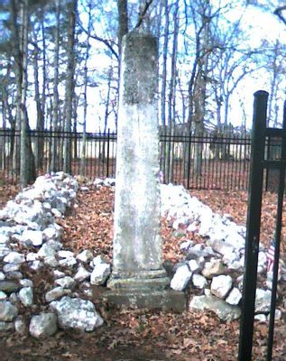
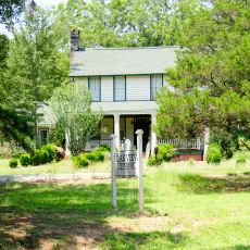
Buford's Massacre Site is a historic location in Lancaster County that marks the site of a Revolutionary War engagement in 1780. The 2-acre grounds contain two monuments, with a newer marker replacing an earlier one that had fallen into disrepair.

The site commemorates a battle in May 1780 when British and American troops clashed, resulting in heavy losses for the colonial forces. This engagement became a turning point that shifted attitudes about the British presence in the region.

The site marks a moment when colonial forces faced overwhelming odds, and this struggle became part of the region's identity. Local memory connects the event to the spirit of resistance that defined the Revolutionary War in the Carolinas.

The site sits along South Carolina Highway 522 near the Buford Community, making it relatively accessible by road. Since the grounds remain privately owned, visitors should confirm access and conditions before planning a visit.

The Jackson family, which would later produce a U.S. president, provided care to wounded soldiers in the aftermath of the battle. This personal connection links a future presidential household to the site's place in American history.

The community of curious travelers

AroundUs brings together thousands of curated places, local tips, and hidden gems, enriched daily by 60,000 contributors worldwide.

Start exploring
Location
GPS coordinates
34.74056,-80.62639
Latest update
December 12, 2025 16:42
Around this place
Landsford Canal State Park
United States of America

Landsford Canal State Park

23.7 km
Andrew Jackson State Park
United States of America

Andrew Jackson State Park

19.9 km
Pleasant Grove Camp Meeting Ground
United States of America

Pleasant Grove Camp Meeting Ground

24.5 km
Mount Carmel A.M.E. Zion Campground
United States of America

Mount Carmel A.M.E. Zion Campground

21.3 km
Landsford Plantation House
United States of America

Landsford Plantation House

26.6 km
Leroy Springs House
United States of America

Leroy Springs House

12.5 km
Monroe Residential Historic District
United States of America

Monroe Residential Historic District

27.5 km
North Carolina-South Carolina Cornerstone
United States of America

North Carolina-South Carolina Cornerstone

17.9 km
Wade-Beckham House
United States of America

Wade-Beckham House

20.9 km
Lancaster Presbyterian Church
United States of America

Lancaster Presbyterian Church

13.7 km
Cureton House
United States of America

Cureton House

21.8 km
Russell-Heath House
United States of America

Russell-Heath House

24.7 km
Craig House
United States of America

Craig House

13 km
Clinton AME Zion Church
United States of America

Clinton AME Zion Church

21.6 km
Dr. William Columbus Cauthen House
United States of America

Dr. William Columbus Cauthen House

20.7 km
Massey-Doby-Nisbet House
United States of America

Massey-Doby-Nisbet House

26.7 km
Waxhaw Historic District
United States of America

Waxhaw Historic District

23 km
John C. Sikes House
United States of America

John C. Sikes House

27.6 km
Lancaster Downtown Historic District
United States of America

Lancaster Downtown Historic District

13.4 km
Lancaster Cotton Oil Company
United States of America

Lancaster Cotton Oil Company

13.2 km
Thomas Walker Huey House
United States of America

Thomas Walker Huey House

11.7 km
Perry-McIlwain-McDow House
United States of America

Perry-McIlwain-McDow House

16.1 km
Robert Barnwell Allison House
United States of America

Robert Barnwell Allison House

12.7 km
Matson Street Historic District
United States of America

Matson Street Historic District

21.8 km
Waxhaw-Weddington Roads Historic District
United States of America

Waxhaw-Weddington Roads Historic District

27.4 km
William Harrison Sapp House
United States of America

William Harrison Sapp House

6.4 km
East Richland Street-East Church Street Historic District
United States of America

East Richland Street-East Church Street Historic District

21.5 km
Lancaster County Courthouse
United States of America

Lancaster County Courthouse

13.7 km
Show the full map
« Buford's Massacre Site - Revolutionary War battlefield in Lancaster County, United States » is provided by Around Us (aroundus.com). Images and texts are derived from Wikimedia project under a Creative Commons license. You are allowed to copy, distribute, and modify copies of this page, under the conditions set by the license, as long as this note is clearly visible.

Discover hidden gems everywhere you go!

From secret cafés to breathtaking viewpoints, skip the crowded tourist spots and find places that match your style. Our app makes it easy with voice search, smart filtering, route optimization, and insider tips from travelers worldwide. Download now for the complete mobile experience.

Around Us App Screenshot

A unique approach to discovering new places

Le Figaro

All the places worth exploring

France Info

A tailor-made excursion in just a few clicks

20 Minutes

Around Us
Travel Guide & Maps
Download

Send to your phone

QR Code
1

Open the camera app on your mobile.

2

Point at the QR code with your camera. A notification will appear.

3

Tap the notification to open the link.