Enable Location

We need your location to show you interesting places around you

Discover nearby places

Find interesting locations and hidden gems around you

Precise directions

Get accurate directions and distances to places

Your location is never shared with other users. It's only used when you tap the location button.

Pearson's Falls

Log in to your account

Start exploring — it's free

Trusted by 65,204 travelers worldwide

Continue with Google
Continue with Apple
or

We will send you a code to connect

By continuing, you accept our Terms and Conditions and our Privacy Policy

Check your inbox

We've sent a pincode in your inbox. Please enter the code below.

Pearson's Falls
Discussion Reviews 1 Photos
3.3k Popularity

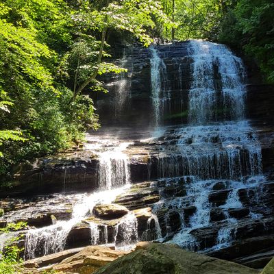
Pearson's Falls, Waterfall in Polk County, North Carolina, United States

Pearson's Falls is a waterfall in Polk County, North Carolina, set within a forested botanical preserve fed by natural springs. The falls drop into a rocky gorge carved by Colt Creek, and the surrounding land holds a wide range of native plants visible along the walking path.

A local garden club bought the land in 1931 to protect it, naming it after a railroad engineer who had come across the falls some years earlier. The site has been managed as a private botanical preserve ever since, without passing into public ownership.

The preserve is a designated birding site, and visitors often stop along the stream to watch native birds moving through the forest canopy. The walking path follows Colt Creek closely, giving a clear sense of how water and woodland interact in this part of the Appalachians.

The trail to the falls is short and manageable for most visitors, but solid footwear helps on sections where the ground is uneven or wet. The preserve is closed during January, so planning a visit outside that month ensures access.

The Smithsonian Institution's Archives of American Gardens has included this site in its records, which is uncommon for a privately managed preserve of this size. That entry reflects how the land has become a reference point for botanical documentation well beyond its local setting.

The community of curious travelers

AroundUs brings together thousands of curated places, local tips, and hidden gems, enriched daily by 60,000 contributors worldwide.

Start exploring
Location
GPS coordinates
35.21920,-82.33220
Latest update
March 3, 2026 13:56
Around this place
Poinsett Bridge
United States of America

Poinsett Bridge

11.1 km
Campbell's Covered Bridge
United States of America

Campbell's Covered Bridge

16.1 km
Henderson County Courthouse
United States of America

Henderson County Courthouse

15.7 km
Stone Hedge
United States of America

Stone Hedge

8.2 km
Mineral and Lapidary Museum
United States of America

Mineral and Lapidary Museum

15.9 km
St. John in the Wilderness
United States of America

St. John in the Wilderness

12.3 km
Flat Rock Historic District
United States of America

Flat Rock Historic District

13.1 km
Pine Crest Inn
United States of America

Pine Crest Inn

9 km
Mills-Screven Plantation
United States of America

Mills-Screven Plantation

7.4 km
Tryon Country Club
United States of America

Tryon Country Club

7.1 km
Main Street Historic District
United States of America

Main Street Historic District

15.9 km
Reese House
United States of America

Reese House

15.8 km
King-Waldrop House
United States of America

King-Waldrop House

15.9 km
Mary Mills Coxe House
United States of America

Mary Mills Coxe House

13.9 km
Church of the Transfiguration
United States of America

Church of the Transfiguration

2.3 km
Ryder Hall
United States of America

Ryder Hall

2.2 km
Blockhouse Site
United States of America

Blockhouse Site

10.7 km
Lynncote
United States of America

Lynncote

8.3 km
Polk County Courthouse
United States of America

Polk County Courthouse

12.7 km
Clarke-Hobbs-Davidson House
United States of America

Clarke-Hobbs-Davidson House

16.1 km
J. G. Hughes House
United States of America

J. G. Hughes House

12.7 km
Seven Hearths
United States of America

Seven Hearths

7.4 km
Charlton Leland
United States of America

Charlton Leland

2.3 km
Seventh Avenue Depot District
United States of America

Seventh Avenue Depot District

16.1 km
Bank of Tryon Building
United States of America

Bank of Tryon Building

8.5 km
Saluda Main Street Historic District
United States of America

Saluda Main Street Historic District

2.4 km
Fox Theatre
United States of America

Fox Theatre

16 km
Green River Branch Library
United States of America

Green River Branch Library

10 km
Show the full map
Reviews
Share your experience

No review yet

Discussions
Start a discussion...

No discussion yet

« Pearson's Falls - Waterfall in Polk County, North Carolina, United States » is provided by Around Us (aroundus.com). Images and texts are derived from Wikimedia project under a Creative Commons license. You are allowed to copy, distribute, and modify copies of this page, under the conditions set by the license, as long as this note is clearly visible.

Discover hidden gems everywhere you go!

From secret cafés to breathtaking viewpoints, skip the crowded tourist spots and find places that match your style. Our app makes it easy with voice search, smart filtering, route optimization, and insider tips from travelers worldwide. Download now for the complete mobile experience.

Around Us App Screenshot

A unique approach to discovering new places

Le Figaro

All the places worth exploring

France Info

A tailor-made excursion in just a few clicks

20 Minutes

Around Us
Travel Guide & Maps
Download

Send to your phone

QR Code
1

Open the camera app on your mobile.

2

Point at the QR code with your camera. A notification will appear.

3

Tap the notification to open the link.