Tocopilla, Port city in northern Antofagasta Region, Chile
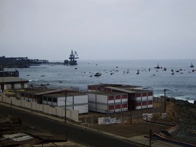
Tocopilla is a port city in the Antofagasta Region along the Pacific coast, stretching along the shoreline with commercial harbors and industrial facilities as its defining features. The urban area includes two beaches separated by industrial structures, and the city handles mineral cargo through its port operations.
The settlement was founded in 1843 as a shipping hub for inland copper mining operations and later became a major export center during the nitrate boom. Its growth as an industrial port has been tied to mining developments in the surrounding region.
The city's identity revolves around port work and maritime life, with locals spending time along the waterfront and at nearby beaches as part of daily routines. The community gathers in public spaces to maintain connections to the ocean that has always been central to their way of life.
The city connects to the Pan-American Highway and has an airport for travel to other regions, making it accessible for visitors. The two beaches are reachable on foot, though industrial zones dominate parts of the landscape and guide your movement through town.
The two beaches, Covadonga and Caleta Boy, are separated so completely by industrial facilities that they feel like two distinct places within the same city, creating an unusual spatial division. This layout forces visitors to cross through industrial zones to move between the two recreational areas, reflecting how work and leisure are woven together here.
The community of curious travelers
AroundUs brings together thousands of curated places, local tips, and hidden gems, enriched daily by 60,000 contributors worldwide.