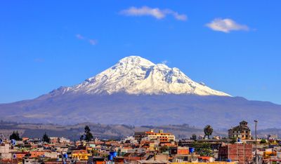
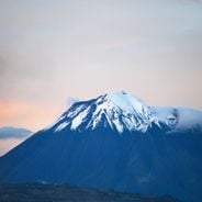
Chimborazo, Stratovolcano in Cordillera Occidental, Ecuador.
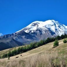
Chimborazo is a stratovolcano in the Cordillera Occidental of Ecuador, with a summit at 6,263 meters (20,548 feet) covered by permanent glaciers. These glaciers have been retreating for decades, yet their meltwater still flows into rivers that supply several provinces.
Edward Whymper climbed to the summit in 1880 as the first documented mountaineer and reached it twice during the same expedition. Before this ascent, the mountain was long considered the highest in the world until more accurate measurements identified other peaks.
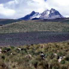
The name comes from the Quechua language and the mountain remains a spiritual reference point for many communities in the Andes in daily life. Hikers on the way to the summit occasionally meet llamas that have been kept here for centuries and are part of the landscape.
The two shelters Carrel at 4,850 meters (15,912 feet) and Whymper at 5,000 meters (16,404 feet) serve as starting points for the ascent to the summit. Climbers should allow several days for acclimatization and check weather conditions carefully before any attempt.
Due to the equatorial bulge, the summit lies farther from the center of the Earth than any other point on the planet, even farther than Everest. This circumstance makes the mountain a special case in geography, although its absolute elevation is lower.
Location: Chimborazo Province
Elevation above the sea: 6,263.47 m
GPS coordinates: -1.46810,-78.81556
Latest update: December 4, 2025 19:01
Ecuador contains photographic subjects from Quito's colonial streets to Galápagos Islands landscapes. The country features architectural monuments, volcanoes, crater lakes, waterfalls and national parks. Locations include the National Vow Basilica, Cotopaxi Volcano, Quilotoa Lake and cultural centers like Otavalo Market.
Cotopaxi volcano
97.2 km
Quilotoa
69.5 km
Tungurahua volcano
40.8 km
Cotopaxi National Park
96.9 km
Sangay National Park
67.3 km
Sangay volcano
79.7 km
Llanganates National Park
74.7 km
El Altar volcano
50.5 km
Cascada el Pailón del Diablo
58.3 km
Illinizas Ecological Reserve
62.1 km
Illiniza volcano
91.8 km
El Chalupas
87.1 km
Chimborazo Fauna Production Reserve
5.2 km
Carihuairazo volcano
9.8 km
Refugio de vida silvestre Pasochoa
118.5 km
Iglesia de La Balbanera
29 km
Corazón volcano
105.6 km
Rumiñahui volcano
104 km
Cathedral Basilica of Our Lady of the Elevation
32.7 km
Nariz del Diablo
86.5 km
Abras de Mantequilla
101.6 km
Atocha-La Liria Botanical Garden
33.3 km
Our Lady of Mercy Cathedral, Babahoyo
87.8 km
Chimborazo
1 km
Our Lady of the Rosary Cathedral, Puyo
91.2 km
Martínez-Holguín House
34.4 km
Mulatos River
103.3 km
Sacred Heart Basilica (Riobamba)
29.7 kmReviews
Visited this place? Tap the stars to rate it and share your experience / photos with the community! Try now! You can cancel it anytime.
Discover hidden gems everywhere you go!
From secret cafés to breathtaking viewpoints, skip the crowded tourist spots and find places that match your style. Our app makes it easy with voice search, smart filtering, route optimization, and insider tips from travelers worldwide. Download now for the complete mobile experience.
A unique approach to discovering new places❞
— Le Figaro
All the places worth exploring❞
— France Info
A tailor-made excursion in just a few clicks❞
— 20 Minutes