Enable Location

We need your location to show you interesting places around you

Discover nearby places

Find interesting locations and hidden gems around you

Precise directions

Get accurate directions and distances to places

Your location is never shared with other users. It's only used when you tap the location button.

Goioerê

Log in to your account

Start exploring — it's free

Trusted by 63,118 travelers worldwide

Continue with Google
Continue with Apple
or

We will send you a code to connect

By continuing, you accept our Terms and Conditions and our Privacy Policy

Check your inbox

We've sent a pincode in your inbox. Please enter the code below.

Discussion Reviews 1 Photos
23.9k Popularity

Goioerê, Municipality in Paraná, Brazil

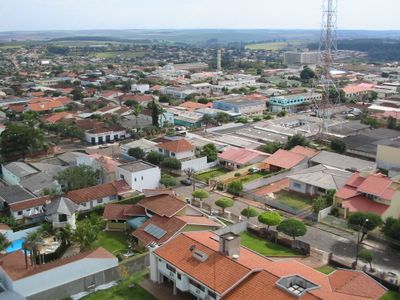
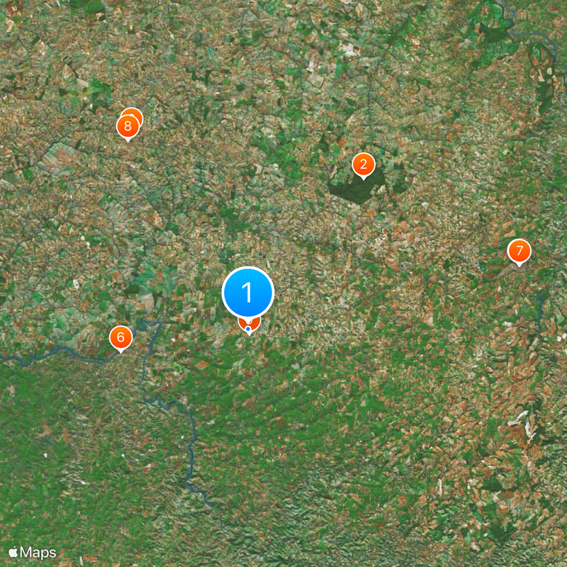
Goioerê is a municipality in Paraná state, situated across fertile agricultural lands in the Centro Ocidental Paranaense region. The town spreads over flat terrain shaped by river systems and marked by extensive farming activity.

The municipality was established on March 28, 1951, developing from a small agricultural settlement into an administrative center. This growth reflected the agricultural development of the region and its expanding role in state commerce.

The name Goioerê comes from the Kaingang indigenous language and means 'field of water', showing how the town's identity connects to the rivers and wetlands that shape the surrounding area.

The town offers basic services including schools, healthcare facilities, and road connections to larger cities throughout Paraná state. The flat landscape makes navigation straightforward, and proximity to main highways facilitates getting around.

The Goioerê River flows through the region as a tributary of the Piquiri River and supplies water for extensive agricultural fields. Visitors can observe how this river system sustains the farming landscape and provides irrigation for diverse crops.

The community of curious travelers

AroundUs brings together thousands of curated places, local tips, and hidden gems, enriched daily by 60,000 contributors worldwide.

Start exploring
Location
Inception
1943
Elevation above the sea
505 m
Shares border with
Rancho Alegre d'Oeste, Quarto Centenário, Moreira Sales, Formosa do Oeste, Janiópolis, Mariluz
GPS coordinates
-24.18500,-53.02778
Latest update
December 20, 2025 13:30
Reviews
Share your experience

No review yet

Discussions
Start a discussion...

No discussion yet

« Goioerê - Municipality in Paraná, Brazil » is provided by Around Us (aroundus.com). Images and texts are derived from Wikimedia project under a Creative Commons license. You are allowed to copy, distribute, and modify copies of this page, under the conditions set by the license, as long as this note is clearly visible.

Discover hidden gems everywhere you go!

From secret cafés to breathtaking viewpoints, skip the crowded tourist spots and find places that match your style. Our app makes it easy with voice search, smart filtering, route optimization, and insider tips from travelers worldwide. Download now for the complete mobile experience.

Around Us App Screenshot

A unique approach to discovering new places

Le Figaro

All the places worth exploring

France Info

A tailor-made excursion in just a few clicks

20 Minutes

Around Us
Travel Guide & Maps
Download

Send to your phone

QR Code
1

Open the camera app on your mobile.

2

Point at the QR code with your camera. A notification will appear.

3

Tap the notification to open the link.