Enable Location

We need your location to show you interesting places around you

Discover nearby places

Find interesting locations and hidden gems around you

Precise directions

Get accurate directions and distances to places

Your location is never shared with other users. It's only used when you tap the location button.

Santo Antônio da Platina

Log in to your account

Start exploring — it's free

Trusted by 61,509 travelers worldwide

Continue with Google
Continue with Apple
or

We will send you a code to connect

By continuing, you accept our Terms and Conditions and our Privacy Policy

Check your inbox

We've sent a pincode in your inbox. Please enter the code below.

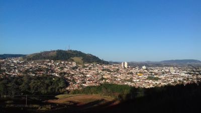
Santo Antônio da Platina, Municipality in Norte Pioneiro Paranaense region, Paraná, Brazil

Description

Santo Antônio da Platina is a municipality located in the Norte Pioneiro Paranaense region at an elevation of approximately 628 meters. The area includes both urban and rural zones, with a mix of built-up districts and agricultural or natural surroundings.

History

The municipality grew from early settlement patterns in Paraná and became an important administrative center for the Norte Pioneiro region. Its development was tied to the opening and expansion of southern Brazil's frontier territories.

Culture

The residents shape daily life through traditions passed down from the immigrant groups who arrived to build their lives here over generations. You notice this heritage in how the community gathers, in local businesses, and in the way people interact with one another.

Practical

The main civic services are organized around Praça Nossa Senhora Aparecida, where administrative offices are located. Public transportation connects to neighboring municipalities, making travel to surrounding areas straightforward.

Did you know?

The economy blends farming with craft and small-scale production, creating a mix of rural and commercial activity. This combination shapes how people work and how the local landscape is used.

Location
Elevation above the sea
628 m
Shares border with
Jacarezinho, Abatiá, Guapirama, Bandeirantes, Barra do Jacaré, Joaquim Távora, Jundiaí do Sul
GPS coordinates
-23.29500,-50.07694
Latest update
December 20, 2025 13:12

AroundUs brings together thousands of curated places, local tips, and hidden gems, enriched daily by 60,000 contributors worldwide. Discover all places nearby (Paraná).

« Santo Antônio da Platina - Municipality in Norte Pioneiro Paranaense region, Paraná, Brazil » is provided by Around Us (aroundus.com). Images and texts are derived from Wikimedia project under a Creative Commons license. You are allowed to copy, distribute, and modify copies of this page, under the conditions set by the license, as long as this note is clearly visible.

Discover hidden gems everywhere you go!

From secret cafés to breathtaking viewpoints, skip the crowded tourist spots and find places that match your style. Our app makes it easy with voice search, smart filtering, route optimization, and insider tips from travelers worldwide. Download now for the complete mobile experience.

Around Us App Screenshot

A unique approach to discovering new places

Le Figaro

All the places worth exploring

France Info

A tailor-made excursion in just a few clicks

20 Minutes

Around Us
Travel Guide & Maps
Download

Send to your phone

QR Code
1

Open the camera app on your mobile.

2

Point at the QR code with your camera. A notification will appear.

3

Tap the notification to open the link.