Enable Location

We need your location to show you interesting places around you

Discover nearby places

Find interesting locations and hidden gems around you

Precise directions

Get accurate directions and distances to places

Your location is never shared with other users. It's only used when you tap the location button.

Log in to your account

Start exploring — it's free

Trusted by 62,834 travelers worldwide

Continue with Google
Continue with Apple
or

We will send you a code to connect

By continuing, you accept our Terms and Conditions and our Privacy Policy

Check your inbox

We've sent a pincode in your inbox. Please enter the code below.

Rio das Flores, Rural municipality in Rio de Janeiro, Brazil

Rio das Flores is a rural municipality in Rio de Janeiro state located on a mountainous plateau. The area is characterized by green hills and agricultural production, particularly coffee and sugarcane distilling.

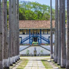
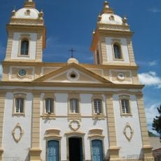
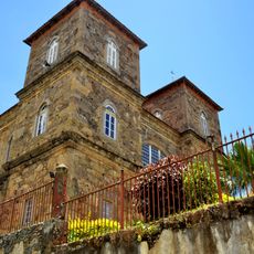
Portuguese settlers arrived in the 16th century and transformed the region from indigenous Purí land into productive territory. The area became a major coffee-growing center as this crop shaped the local economy for centuries.

The annual Coffee, Cachaça and Chorinho festival celebrates local traditions and regional food specialties from the mountains. Visitors can experience live music, local crafts, and the culinary heritage that defines the area.

The municipality is accessible by bus from neighboring cities, with visitor information available at the central administrative office. Roads can be winding due to the hilly terrain, so traveling during daylight hours is recommended.

The municipality changed its name from Santa Teresa to Rio das Flores in 1943 to reflect the abundant plant life along its waterways. This renaming marks an important moment when local identity became tied to the region's natural character.

The community of curious travelers

AroundUs brings together thousands of curated places, local tips, and hidden gems, enriched daily by 60,000 contributors worldwide.

Start exploring
Location
Elevation above the sea
583 m
Shares border with
Belmiro Braga, Paraíba do Sul, Santa Bárbara do Monte Verde, Valença, Vassouras
GPS coordinates
-22.16778,-43.58583
Latest update
December 20, 2025 14:49
« Rio das Flores - Rural municipality in Rio de Janeiro, Brazil » is provided by Around Us (aroundus.com). Images and texts are derived from Wikimedia project under a Creative Commons license. You are allowed to copy, distribute, and modify copies of this page, under the conditions set by the license, as long as this note is clearly visible.

Discover hidden gems everywhere you go!

From secret cafés to breathtaking viewpoints, skip the crowded tourist spots and find places that match your style. Our app makes it easy with voice search, smart filtering, route optimization, and insider tips from travelers worldwide. Download now for the complete mobile experience.

Around Us App Screenshot

A unique approach to discovering new places

Le Figaro

All the places worth exploring

France Info

A tailor-made excursion in just a few clicks

20 Minutes

Around Us
Travel Guide & Maps
Download

Send to your phone

QR Code
1

Open the camera app on your mobile.

2

Point at the QR code with your camera. A notification will appear.

3

Tap the notification to open the link.