El Alto, Administrative city in La Paz Metropolitan Area, Bolivia
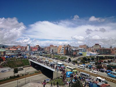
El Alto spreads across a flat plateau sitting at 4,061 meters (13,320 feet) elevation and forms a large commercial and residential area directly next to La Paz. Wide streets run through the sprawling urban expanse with low brick buildings and busy street markets overlooked by surrounding Andean peaks.
The settlement began in the early 1900s as a home for railway workers building connections to Lake Titicaca. It became independent from La Paz on March 6, 1987, and quickly developed into one of the fastest growing urban centers in South America.
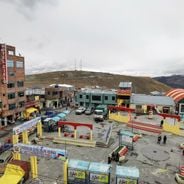
The name means "The Heights," referring to its position on the altiplano where vendors sell traditional textiles and herbal remedies in open-air markets. Street parades during local celebrations feature dancers in feathered costumes and brass bands playing Andean music that echoes across the flat terrain.
The Mi Teleférico cable car system connects the city with La Paz through several color-coded lines serving commuters and visitors. The extreme elevation requires slow movement upon arrival to help adjust to the thin air.
Cholet buildings rise across the cityscape as multi-story structures with bright colors and curved balconies that combine traditional Aymara patterns with contemporary urban construction. These eye-catching buildings were designed by local architects and serve as commercial and residential spaces for successful indigenous entrepreneurs.
The community of curious travelers
AroundUs brings together thousands of curated places, local tips, and hidden gems, enriched daily by 60,000 contributors worldwide.