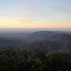
Serra de Baturité, Mountain range in Ceará, Brazil
Serra de Baturité is a mountain range that extends across several municipalities in northern Ceará. The landscape features different ecosystems at varying elevations with natural water sources flowing through the valleys and various rock formations.
The region was designated as an environmental protection area in 1990 as one of the first in Ceará state. Since then it has become a focus for conservation efforts and sustainable management of natural resources.
The name Baturité also refers to the massif and to the municipality on its lower slopes, while Guaramiranga lends the range its alternative name, Serra de Guaramiranga. The higher towns such as Guaramiranga (865 m), Aratuba (830 m) and Mulungu (801 m) sit above the hot lowlands, and the range's waterfalls, including the Cachoeira do Chuvisco, one of the sources of the Ceará River, are named stops on local itineraries.
The range spans twelve municipalities, with Guaramiranga (865 m), Aratuba (830 m) and Mulungu (801 m) as the highest town bases; Baturité sits far lower at 175 m. Temperatures range from 15 °C to 22 °C, with minima of 15 °C between June and August. Trails exist at all levels, and the waterfalls of Volta, Frade, Perigo, Chuvisco, Oratório, Cafundó and Jordão are among the marked stops.
The area sits at a water divide where water flows toward different major rivers. This geographic position creates numerous waterfalls and streams that visitors encounter along the trails.
The community of curious travelers
AroundUs brings together thousands of curated places, local tips, and hidden gems, enriched daily by 92,887 contributors worldwide.