Isalo National Park, National park in Ihorombe, Madagascar
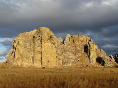
Isalo National Park is a nature reserve covering roughly 81,540 hectares of sandstone formations that create deep canyons, gorges, and plateaus shaped by millions of years of natural erosion. The terrain reveals layers of geology that tell the story of how water and weather transformed the rock.
The park was established as a national park in 1962 and came under the authority of Madagascar National Parks in 1997. This transition formalized protection of the area for future generations.
The land is sacred to the Bara people, who bury their ancestors here and raise zebu cattle in the surrounding grasslands. These practices continue to shape daily life in the region today.
Visitors need to arrange guided tours through Ranohira town, as independent exploration is not permitted. Trails range from short daytime walks to multi-day treks depending on fitness and interest.
The park is home to 77 bird species, including Madagascar's Benson's rock thrush, along with 14 lemur species and plants that have adapted specifically to sandstone environments. This variety reflects how the isolated plateau creates its own ecosystem.
GPS coordinates: -22.42646,45.28385
Latest update: December 6, 2025 16:02
Madagascar features natural landscapes ranging from the baobab avenues near Morondava to the limestone formations of the Tsingy and coastal areas with coral reefs. The country's national parks protect tropical rainforests inhabited by lemurs, along with geological features including crater lakes and sandstone formations. The highest peaks rise in the northern mountain ranges, while the southern regions are characterized by dry landscapes. Photogenic locations include the Isalo Massif with its eroded sandstone canyons, the Masoala Peninsula with its rainforests along the Indian Ocean, and the island of Nosy Be off the northwest coast. The beaches at Ifaty and Anakao attract visitors for their reefs, while Sainte-Marie Island is known for whale watching between July and September. The Kirindy forests in the west are home to nocturnal lemurs and fossas. Historic sites include the royal hill of Ambohimanga, a UNESCO World Heritage site, and the Rova palace in Antananarivo. The geysers at Ampefy and the crater lake Tritriva showcase the volcanic history of the highlands. The red Tsingy near Sadjoavato formed through erosion of iron-rich sandstone and contrast with the gray limestone Tsingy in the west.
Aloalo
110.6 km
Littoral de Toliara
79.7 km
Canyon des Rats
11.3 km
Piscine Naturelle
17.6 km
Cascade des Nymphes
15.6 km
Reine de l'Isalo
23.2 km
Jardin Botanique Ambatos
13.3 km
Piscine noire et bleue
15.4 km
Jardin Botanique
22 km
Tsingy
18 km
Loup de l'Isalo
20.6 km
Isalo Window
24 km
Kianjan'ny Mopera
31.3 km
Color Line
31.5 km
Ampasimaiky
17.5 km
Hill, scenic viewpoint, mountain, summit
12.3 km
Scenic viewpoint
15.4 km
Tapia
16.1 km
La Fenêtre
24 km
Table mountains
39.8 km
Scenic viewpoint
16.4 km
Scenic viewpoint
24.8 km
Petit Nazareth
17.4 km
Tombeau Sakalava
13 km
Memorial
87.1 km
Memorial
87 km
Stelle Vehivavy 8 Mars
30.4 km
Waterfall
15.4 kmReal people, real opinions — but not verified.
Visited this place? Tap the stars to rate it and share your experience / photos with the community! Try now! You can cancel it anytime.
There are very beautiful hikes to be done in this park that resembles the Wild West!
Discover hidden gems everywhere you go!
From secret cafés to breathtaking viewpoints, skip the crowded tourist spots and find places that match your style. Our app makes it easy with voice search, smart filtering, route optimization, and insider tips from travelers worldwide. Download now for the complete mobile experience.
A unique approach to discovering new places❞
— Le Figaro
All the places worth exploring❞
— France Info
A tailor-made excursion in just a few clicks❞
— 20 Minutes
