La Cheminée, Mountain summit in French Southern Territories, France.
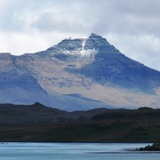
La Cheminée is a mountain peak in the French Southern Territories that rises approximately 616 meters above sea level. The summit sits in a remote location that remains largely isolated and is visited primarily by research teams and explorers.
The peak was mapped and documented during scientific surveys of the French Southern Territories, receiving its name through expeditions that explored the region. This recording established it as a reference point for geographical and geological research activities.
The mountain serves as a reference point for scientific expeditions in the French Southern Territories, contributing to geological research activities.
The summit sits in an extremely remote location in the southern ocean and is only accessible with special permission and equipment. Visitors should expect harsh local conditions and should prepare thoroughly before attempting to reach this peak.
The mountain's position in the southern hemisphere creates specific weather patterns, affecting climbing conditions throughout different seasons.
The community of curious travelers
AroundUs brings together thousands of curated places, local tips, and hidden gems, enriched daily by 60,000 contributors worldwide.