Enable Location

We need your location to show you interesting places around you

Discover nearby places

Find interesting locations and hidden gems around you

Precise directions

Get accurate directions and distances to places

Your location is never shared with other users. It's only used when you tap the location button.

Log in to your account

Start exploring — it's free

Trusted by 63,528 travelers worldwide

Continue with Google
Continue with Apple
or

We will send you a code to connect

By continuing, you accept our Terms and Conditions and our Privacy Policy

Check your inbox

We've sent a pincode in your inbox. Please enter the code below.

Pic Guynemer
Discussion Reviews Photo
400+ Popularity

Pic Guynemer, Mountain summit in Kerguelen Islands, France.

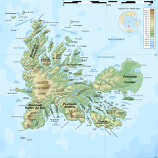
Pic Guynemer is a mountain summit located on Grande Terre in the Kerguelen Islands, situated between Laissez-Porter Bay and Penfeld Bay in the Indian Ocean. The peak reaches approximately 1,088 meters in elevation and forms part of the archipelago's broader geological structure.

A German expedition aboard the Gazelle first documented the peak in 1874, initially naming it Richthofen-Eis after geologist Ferdinand von Richthofen. The current name was introduced later as recognition of an important figure in French military aviation.

The peak was named in 1922 to honor Georges Guynemer, a French fighter pilot from World War I. The name reflects respect for his contributions to aviation history.

Climbing requires arranging access through the Port-aux-Français research station and preparing for harsh weather conditions that dominate the region. Proper mountain gear and experience in polar environments are essential for any ascent.

The peak stands near Mount Mermoz and experiences direct exposure to Southern Ocean wind patterns that continuously shape its landscape. This exposed location makes it scientifically valuable for studying extreme wind phenomena in remote polar regions.

The community of curious travelers

AroundUs brings together thousands of curated places, local tips, and hidden gems, enriched daily by 60,000 contributors worldwide.

Start exploring
GPS coordinates
-49.13194,68.98583
Latest update
December 14, 2025 20:25
Reviews
Share your experience

No review yet

Discussions
Start a discussion...

No discussion yet

« Pic Guynemer - Mountain summit in Kerguelen Islands, France » is provided by Around Us (aroundus.com). Images and texts are derived from Wikimedia project under a Creative Commons license. You are allowed to copy, distribute, and modify copies of this page, under the conditions set by the license, as long as this note is clearly visible.

Discover hidden gems everywhere you go!

From secret cafés to breathtaking viewpoints, skip the crowded tourist spots and find places that match your style. Our app makes it easy with voice search, smart filtering, route optimization, and insider tips from travelers worldwide. Download now for the complete mobile experience.

Around Us App Screenshot

A unique approach to discovering new places

Le Figaro

All the places worth exploring

France Info

A tailor-made excursion in just a few clicks

20 Minutes

Around Us
Travel Guide & Maps
Download

Send to your phone

QR Code
1

Open the camera app on your mobile.

2

Point at the QR code with your camera. A notification will appear.

3

Tap the notification to open the link.