Kokerbin Rock, Rock formation in Bruce Rock Shire, Western Australia.
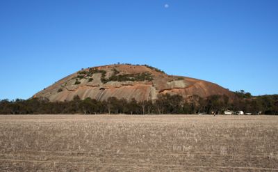
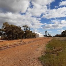
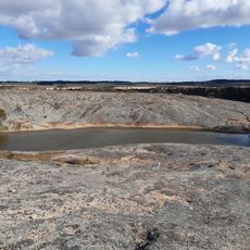
Kokerbin Rock is a granite formation in Western Australia's Wheatbelt region that spans across 9 hectares and rises about 122 meters above ground. The formation contains distinctive geological features such as wave patterns, Dog Rock, and a collection of rounded stones called Devil's Marbles.
The formation was first documented in 1836 by John Septimus Roe during his exploration of Western Australia's interior. This early record marked the beginning of European documentation of this geological site.
The Nyaki Nyaki Noongar First Nation people named this site Kokerbin, which means high place in their language. This name reflects how important this location was to the area's original inhabitants.
The eastern section has restroom facilities and a designated picnic area with established pathways leading to caves and the summit. The site is easy to explore on foot and visitors should plan time to see the different areas and trails.
The rock surface displays wave-like patterns that formed through natural erosion processes, giving the place its distinctive look. These patterns tell the story of millions of years of geological history carved into the stone.
Location: Shire of Bruce Rock
Elevation above the sea: 122 m
GPS coordinates: -31.88898,117.70678
Latest update: December 12, 2025 14:22
St Francis Xavier Roman Catholic Church of Quairading
31.9 km
Merredin Railway Museum
70.5 km
Corrigin Town Hall
51.6 km
Court House
70.8 km
Merredin Post Office
70.6 km
Merredin District Hall
70.8 km
Agricultural Hall, Kellerberrin
28.6 km
Beverley Court House
77.5 km
Roads Board Hall and Gardens
51.5 km
Kellerberrin Post Office & Residence
28.4 km
St Andrew's Anglican Church & Cemetery, Greenhills
69.3 km
Cummins Theatre
70.8 km
Beverley Judicial Complex
77.4 km
Merredin Public Library
70.7 km
Merredin Cinema
70.4 km
2/1 Australian General Hospital (ruins), Merredin
72.4 km
Railway Water Tower, Cunderdin
51.4 km
Narembeen Civic Precinct
67.9 km
Merredin Railway Water Tank
70.6 km
Narembeen Roads Board Building
67.9 km
Narembeen Public Hall
67.9 km
Bullaring grain receival point
67.9 km
Cunderdin grain receival point
51.6 km
Kellerberrin Fire Station
28.4 km
Gorge Rock Nature Reserve
69 km
Corrigin Town Hall & Road Board Office
51.6 km
Bills Horse Trough, Merredin
70.7 km
Bruce Rock Shire Offices
41.8 kmVisited this place? Tap the stars to rate it and share your experience / photos with the community! Try now! You can cancel it anytime.
Discover hidden gems everywhere you go!
From secret cafés to breathtaking viewpoints, skip the crowded tourist spots and find places that match your style. Our app makes it easy with voice search, smart filtering, route optimization, and insider tips from travelers worldwide. Download now for the complete mobile experience.
A unique approach to discovering new places❞
— Le Figaro
All the places worth exploring❞
— France Info
A tailor-made excursion in just a few clicks❞
— 20 Minutes