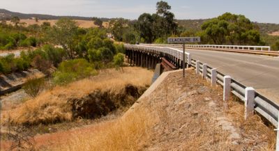
Clackline Bridge, Bicycle bridge and residential street in Clackline, Western Australia.
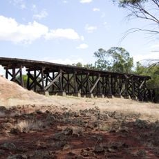
Clackline Bridge is a timber bridge connecting two residential areas and functioning as a local road. It has a curved shape supported by multiple piers and crosses both a creek valley and the route of a former railway line.
The bridge was constructed in 1935 and originally carried main road traffic until a bypass route opened in 2008, which diverted through traffic away. Since then it has primarily served local connections and stands as a record of how transportation patterns changed in this area.
The bridge remains significant to locals as a preserved structure from early industrial times in the region. It shows how transportation routes were built in this area and is now regarded as an important part of how people understand their local history.
The bridge is freely accessible and used daily by residents traveling between neighborhoods. Visitors should expect local vehicle traffic and be aware that surface conditions can vary depending on weather.
The bridge crosses both a creek bed and the alignment of a closed railway line simultaneously, a combination rarely seen. This dual function makes it a technically interesting example of practical engineering from an earlier era.
The community of curious travelers
AroundUs brings together thousands of curated places, local tips, and hidden gems, enriched daily by 60,000 contributors worldwide.