Bungle Bungle Range, Mountain range in Kimberley region, Western Australia.
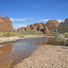
Bungle Bungle Range is a sandstone massif in the Kimberley whose beehive-shaped domes rise 200 to 300 m above the surrounding plain, reaching 578 m at their highest point. Horizontal bands of orange, rust-red and dark grey run across the rounded tops and fluted sides, and the domes meet a flat grey rock surface marked by wavy lines. The formation covers about 450 sq km.
The sandstone and conglomerate beds were laid down in the Red Basin 375 to 350 million years ago, eroded from northern ranges and carried by river systems. Tectonic movements lifted the block about 250 million years ago and again around 20 million years ago; the beehive domes formed after the later uplift. The range stayed known only to Kija Aboriginal people and stockmen until a film team flew over it in 1982–1983; the area became a national park in 1987 and a UNESCO World Heritage Site in 2003.
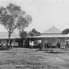
The Gija people know the range as Purnululu, their word for sandstone, and have lived in the area for over 20,000 years. In their creation story, the Brolga stole the community's water; the Frog struck it with a boomerang, and the falling water formed the landscape. The name Bungle Bungle comes from a farm established in 1930 northwest of the range, named by Arthur Muggleton, though the etymology is unclear and may be a corruption of Purnululu or of the grass bundle bundle.
Visitors need four-wheel-drive vehicles to travel the unsealed roads leading to the range, as access is challenging in places. Visit between April and October for the most comfortable conditions.
Deep within the range sits a circular depression about 7 kilometers across, created by an ancient meteorite impact. This site, called Piccaninny Crater, reveals how space rocks shaped the landscape.
The community of curious travelers
AroundUs brings together thousands of curated places, local tips, and hidden gems, enriched daily by 94,152 contributors worldwide.