Donggala, Administrative region in Central Sulawesi, Indonesia
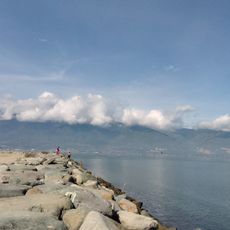
Donggala is a regency in Central Sulawesi that encompasses mountainous terrain and coastal areas overlooking the Makassar Strait. The region consists of sixteen administrative districts with Banawa serving as the government and administrative center.
Before Dutch colonial control began in 1904, the territory consisted of eight independent kingdoms including Palu, Sigi Dolo, and Kulawi. These separate kingdoms shaped the region's development until colonial administration took hold.
Local weavers create traditional sarongs with patterns that reflect regional identity and craft knowledge passed down through families. This textile work remains an important part of daily community life and economic activity.
The region is divided into two separate sections, which visitors should keep in mind when planning their route through the area. Banawa serves as the main administrative hub and is the best starting point for exploring the different districts.
The regency splits into two non-contiguous sections with Palu City sitting between them, creating an unusual administrative arrangement. This geographical division is a distinctive feature that sets it apart from most other regional territories.
The community of curious travelers
AroundUs brings together thousands of curated places, local tips, and hidden gems, enriched daily by 60,000 contributors worldwide.