Cape Leveque, Remote cape in Dampier Peninsula, Western Australia
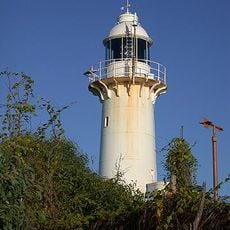
Cape Leveque is the northernmost tip of the Dampier Peninsula in the Kimberley region of Western Australia, 240 km by road north of Broome. Its 13.3-metre lighthouse, commissioned on 9 August 1911, stands at a focal plane of 43 metres and marks the western entrance of King Sound. About 450 metres offshore lies Leveque Island, 5.16 hectares in area.
Cape Leveque was named by Captain Nicolas Baudin after his hydrographer, Pierre Lévêque. The 13.3-metre lighthouse was commissioned on 9 August 1911, marking the western entrance of King Sound. Its light shows three flashes every twenty seconds from a focal plane of 43 metres. The Bardi people are the traditional owners of the cape.
Cape Leveque lies in the country of the Bardi people, its traditional owners. Their shell middens, large mounds of discarded shells, stand beside the small caravan park on the shore of the Indian Ocean, evidence of long use of the cape as a camping ground. The cape's name comes from Pierre Lévêque, hydrographer to Captain Nicolas Baudin, who charted this coast.
Access involves a long drive north from Broome on unsealed roads that require four-wheel drive during wet seasons. Plan extra time and check road conditions before traveling, as the route is remote.
Shell middens line the shoreline, revealing centuries of Aboriginal use of this coastal area. The waters around this cape also attract migrating whales and nesting sea turtles.
The community of curious travelers
AroundUs brings together thousands of curated places, local tips, and hidden gems, enriched daily by 93,506 contributors worldwide.