Dip Falls, Cascade waterfall in Mawbanna, Tasmania, Australia
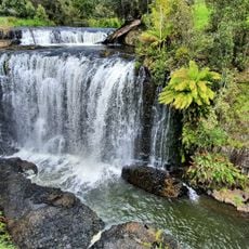
Dip Falls is a two-tiered cascade in Mawbanna that flows over cubic basalt formations, reaching heights between 22 and 34 meters. The water moves across the dark stone surface of Dip River, creating distinct patterns on the rock face.
Dip Falls lies within the Dip Range Regional Reserve, a protected area in Tasmania's north-west. The falls drop 22 to 34 metres over cubic basalt on the Dip River, about 36 kilometres southeast of Stanley via the Bass Highway and near the village of Sisters Beach. The reserve sits at an elevation of 218 metres above sea level.
The falls and nearby Big Tree serve as recognizable natural landmarks within Dip Range Regional Reserve, shaping how visitors experience northwest Tasmania's landscape. Both sites draw people interested in exploring the region's geological formations.
The falls are reached via two main trails from the car park, with one leading to a wheelchair-accessible upper lookout and another featuring a staircase to the lower viewing area. Both routes offer different perspectives of the water flow and allow visitors to choose based on their mobility and interests.
The cascade drops 22 to 34 metres over rock the sources describe as cubic basalt, not hexagonal columns. It lies at 218 metres above sea level in the Dip Range Regional Reserve, about 36 kilometres southeast of Stanley via the Bass Highway, near Sisters Beach.
The community of curious travelers
AroundUs brings together thousands of curated places, local tips, and hidden gems, enriched daily by 94,413 contributors worldwide.