Alamo Canal

Log in to your account

AroundUs is a community-driven map of interesting places, built by curious explorers like you. It grows with every review, story, and photo you share.
Connect to save your favorite spots, contribute locations, and create personalized routes.
By continuing, you accept our Terms and Conditions and our Privacy Policy
Add to collection
Map
Suggest a change
Share

Alamo Canal, Border irrigation canal between Imperial Valley, United States and Mexicali, Mexico

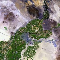
The Alamo Canal is an irrigation system that extends across Mexican and American territory, directing water from the Colorado River to the Alamo River. It is controlled by gates, pumps, and lift stations that distribute water to farms on both sides of the border.

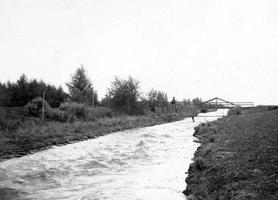
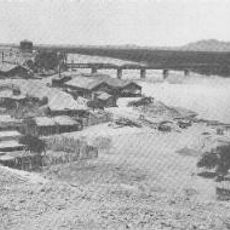
The canal was planned and built around 1900 under George Chaffey's leadership to bring water to drier areas. An uncontrolled breach between 1904 and 1906 had unexpected consequences for the region.

The canal connects farming communities on both the Mexican and American sides, flowing as a shared waterway that sustains agriculture for people across the border. Residents in both regions depend on this system for their livelihoods.

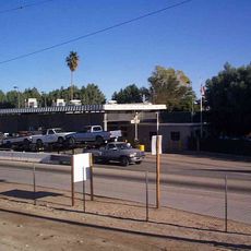
The system is accessible at various points, but many areas are reserved for agricultural use and may require permission to enter. It helps to check water flow conditions during different seasons, as these vary depending on farming needs.

An uncontrolled breach in the canal between 1904 and 1906 led to the formation of the Salton Sea, which is now California's largest lake. This event shows how an irrigation structure inadvertently created an entirely new geographic landscape.

GPS coordinates: 32.64206,-114.85594

Latest update: December 8, 2025 13:43

Photos
Around this place
Old Plank Road
United States of America

Old Plank Road

9.8 km
Desert Sun Stadium
United States of America

Desert Sun Stadium

20.7 km
Ocean To Ocean Bridge
United States of America

Ocean To Ocean Bridge

24.5 km
Yuma Crossing
United States of America

Yuma Crossing

24.5 km
Andrade Port of Entry
United States of America

Andrade Port of Entry

14.7 km
Pilot Knob
United States of America

Pilot Knob

14.1 km
Yuma Quartermaster Depot State Historic Park
United States of America

Yuma Quartermaster Depot State Historic Park

23.4 km
Hermosillo
Mexico

Hermosillo

16 km
Brown House
United States of America

Brown House

23.8 km
St. Paul's Episcopal Church
United States of America

St. Paul's Episcopal Church

23.5 km
United States Post Office–Yuma Main
United States of America

United States Post Office–Yuma Main

24 km
Masonic Temple
United States of America

Masonic Temple

23.8 km
Methodist Episcopal Church
United States of America

Methodist Episcopal Church

23.8 km
Blaisdell Slow Sand Filter Washing Machine
United States of America

Blaisdell Slow Sand Filter Washing Machine

24.3 km
Southern Pacific Railroad Passenger Coach Car-S.P. X7
United States of America

Southern Pacific Railroad Passenger Coach Car-S.P. X7

23.9 km
Ortiz House
United States of America

Ortiz House

23.9 km
Cactus Press-Plaza Paint Building
United States of America

Cactus Press-Plaza Paint Building

24 km
Yuma County Courthouse
United States of America

Yuma County Courthouse

23.8 km
Jerry Kent House
United States of America

Jerry Kent House

23.4 km
Yuma City Hall
United States of America

Yuma City Hall

24 km
Gandolfo Theatre
United States of America

Gandolfo Theatre

23.8 km
Frank Ewing House
United States of America

Frank Ewing House

23.3 km
Balsz House
United States of America

Balsz House

23.6 km
J. Homer Smith House
United States of America

J. Homer Smith House

23.2 km
Brownstetter House
United States of America

Brownstetter House

23 km
Caruthers House
United States of America

Caruthers House

23.5 km
Ruth Ewing House
United States of America

Ruth Ewing House

23.3 km
Yuma Theater
United States of America

Yuma Theater

24 km
Show the full map
Reviews

Visited this place? Tap the stars to rate it and share your experience / photos with the community! Try now! You can cancel it anytime.

« Alamo Canal - Border irrigation canal between Imperial Valley, United States and Mexicali, Mexico » is provided by Around Us (aroundus.com). Images and texts are derived from Wikimedia project under a Creative Commons license. You are allowed to copy, distribute, and modify copies of this page, under the conditions set by the license, as long as this note is clearly visible.

Discover hidden gems everywhere you go!

From secret cafés to breathtaking viewpoints, skip the crowded tourist spots and find places that match your style. Our app makes it easy with voice search, smart filtering, route optimization, and insider tips from travelers worldwide. Download now for the complete mobile experience.

Around Us App Screenshot

A unique approach to discovering new places

Le Figaro

All the places worth exploring

France Info

A tailor-made excursion in just a few clicks

20 Minutes