Chest opened
+${chestReward.xp} XP
Explorer
NOUVEAU ×${chestReward.collectible.quantity}
tapez pour fermer
Chest locked

Open chests in the app

Around Us is built for your phone — chests unlock when you walk, explore and capture nearby places.

Enable Location

We need your location to show you interesting places around you

Discover nearby places

Find interesting locations and hidden gems around you

Precise directions

Get accurate directions and distances to places

Your location is never shared with other users. It's only used when you tap the location button.

Yuma Desert

Log in to your account

Start exploring — it's free

Trusted by 72,889 travelers worldwide

Continue with Google
Continue with Apple
or

We will send you a code to connect

By continuing, you accept our Terms and Conditions and our Privacy Policy

Check your inbox

We've sent a pincode in your inbox. Please enter the code below.

Yuma Desert
Discussion Reviews 1 Photos
17k Popularity

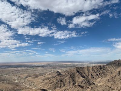
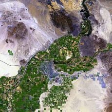
Yuma Desert, Desert region in southwestern Arizona and northwestern Sonora, United States and Mexico.

The Yuma Desert is a flat expanse of sand and dunes located between the Colorado River and the Gila River in the southwestern region. The landscape consists of rolling sandy terrain with sparse low-growing vegetation scattered across the plains.

The desert formed over millions of years through geological processes and later became a crucial crossing point during westward expansion in the 1800s. Indigenous peoples inhabited and traveled through this land long before it became a route for American settlers.

Local communities learned to work with the land by knowing which plants provide food and where hidden water sources appear. These survival methods shaped how people today understand and move through the region.

The best time to visit is between October and March when temperatures are more comfortable and stay below 100°F (37°C). Bring plenty of water, use a reliable vehicle, and protect yourself from the sun since shade is extremely limited in this open landscape.

The Colorado River marks a natural boundary where certain cacti like the saguaro grow only on the eastern side of the region. This geological division creates two distinct ecosystems on opposite banks of the same river.

The community of curious travelers

AroundUs brings together thousands of curated places, local tips, and hidden gems, enriched daily by 60,000 contributors worldwide.

Start exploring
GPS coordinates
32.52783,-114.57106
Latest update
December 7, 2025 19:25
Around this place
Yuma Territorial Prison
United States of America

Yuma Territorial Prison

22.5 km
Desert Sun Stadium
United States of America

Desert Sun Stadium

16.3 km
Ocean To Ocean Bridge
United States of America

Ocean To Ocean Bridge

22.7 km
Yuma Crossing
United States of America

Yuma Crossing

22.7 km
Andrade Port of Entry
United States of America

Andrade Port of Entry

25.8 km
Pilot Knob
United States of America

Pilot Knob

28.2 km
Yuma Quartermaster Depot State Historic Park
United States of America

Yuma Quartermaster Depot State Historic Park

22.8 km
Mission Puerto de Purísima Concepción
United States of America

Mission Puerto de Purísima Concepción

23 km
Brown House
United States of America

Brown House

22.1 km
St. Paul's Episcopal Church
United States of America

St. Paul's Episcopal Church

21.4 km
United States Post Office–Yuma Main
United States of America

United States Post Office–Yuma Main

22 km
Masonic Temple
United States of America

Masonic Temple

22.4 km
Methodist Episcopal Church
United States of America

Methodist Episcopal Church

22.1 km
Blaisdell Slow Sand Filter Washing Machine
United States of America

Blaisdell Slow Sand Filter Washing Machine

22.6 km
Southern Pacific Railroad Passenger Coach Car-S.P. X7
United States of America

Southern Pacific Railroad Passenger Coach Car-S.P. X7

22.8 km
Ortiz House
United States of America

Ortiz House

22.2 km
Cactus Press-Plaza Paint Building
United States of America

Cactus Press-Plaza Paint Building

22.1 km
Yuma County Courthouse
United States of America

Yuma County Courthouse

22.3 km
Jerry Kent House
United States of America

Jerry Kent House

21.8 km
Yuma City Hall
United States of America

Yuma City Hall

22.5 km
Gandolfo Theatre
United States of America

Gandolfo Theatre

22.3 km
Frank Ewing House
United States of America

Frank Ewing House

21.3 km
Balsz House
United States of America

Balsz House

21.8 km
J. Homer Smith House
United States of America

J. Homer Smith House

21.5 km
Brownstetter House
United States of America

Brownstetter House

21.5 km
Caruthers House
United States of America

Caruthers House

21.8 km
Ruth Ewing House
United States of America

Ruth Ewing House

21.3 km
Westwind Golf Course
United States of America

Westwind Golf Course

18.8 km
Show the full map
Reviews
Share your experience

No review yet

Discussions
Start a discussion...

No discussion yet

« Yuma Desert - Desert region in southwestern Arizona and northwestern Sonora, United States and Mexico » is provided by Around Us (aroundus.com). Images and texts are derived from Wikimedia project under a Creative Commons license. You are allowed to copy, distribute, and modify copies of this page, under the conditions set by the license, as long as this note is clearly visible.

Discover hidden gems everywhere you go!

From secret cafés to breathtaking viewpoints, skip the crowded tourist spots and find places that match your style. Our app makes it easy with voice search, smart filtering, route optimization, and insider tips from travelers worldwide. Download now for the complete mobile experience.

Around Us App Screenshot

A unique approach to discovering new places

Le Figaro

All the places worth exploring

France Info

A tailor-made excursion in just a few clicks

20 Minutes

Around Us
Travel Guide & Maps
Download

Send to your phone

QR Code
1

Open the camera app on your mobile.

2

Point at the QR code with your camera. A notification will appear.

3

Tap the notification to open the link.