Sierra Ancha Tank, reservoir in Gila County, Arizona, United States of America
Location: Arizona
Location: Gila County
GPS coordinates: 34.00595,-110.60006
Latest update: November 14, 2025 05:56
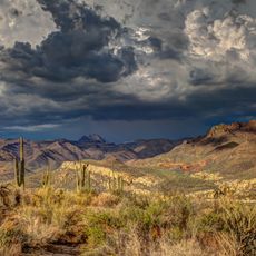
Sierra Ancha Wilderness
32.9 km
Cedar Canyon Bridge
36.5 km
Pleasant Valley Ranger Station
33.7 km
Pinedale Ranger Station
33 km
Deer Springs Lookout Complex
37.3 km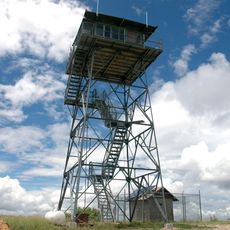
Aztec Peak Lookout
35.7 km
Caddo Point
8.8 km
Big Spring Canyon
17.6 km
Naegelin Rim
36.5 km
Mule Creek Point
36.8 km
White Ledges
35.2 km
Canyon Creek Point
37.9 km
North OW Point
37.5 km
Nelson Lake Point
36.1 km
Lower Corral Rapid
36.8 km
Corkscrew Rapid
39.3 km
Bull Canyon Viewpoint
35.7 km
Nelson Lake Point
35.9 km
Bull Canyon Viewpoint
36.6 km
Travis Walton's Abduction Site
33 km
Scenic viewpoint
38.2 km
Scenic viewpoint
24.9 km
Workman Creek Falls
37 km
Waterfall
34.5 km
Waterfall
34.6 km
Waterfall
30 km
Waterfall
25.9 km
Waterfall
36.7 kmReviews
Visited this place? Tap the stars to rate it and share your experience / photos with the community! Try now! You can cancel it anytime.
Discover hidden gems everywhere you go!
From secret cafés to breathtaking viewpoints, skip the crowded tourist spots and find places that match your style. Our app makes it easy with voice search, smart filtering, route optimization, and insider tips from travelers worldwide. Download now for the complete mobile experience.

A unique approach to discovering new places❞
— Le Figaro
All the places worth exploring❞
— France Info
A tailor-made excursion in just a few clicks❞
— 20 Minutes