Gila Wilderness

Log in to your account

AroundUs is a community-driven map of interesting places, built by curious explorers like you. It grows with every review, story, and photo you share.
Connect to save your favorite spots, contribute locations, and create personalized routes.
Continue with Google
Continue with Apple
Continue with X
Continue with Facebook
Continue with email
By continuing, you accept our Terms and Conditions and our Privacy Policy
Create an account
Add to collection
Map
Suggest a change
Share

Gila Wilderness, Protected wilderness area in southwestern New Mexico, US.

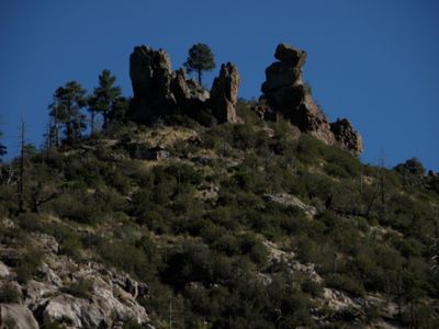
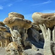
Gila Wilderness is a protected area in southwestern New Mexico, covering roughly 558,000 acres that include three forks of the river and elevations from 4850 to 10,895 feet (1480 to 3320 meters). The terrain consists of forested mountain slopes, deep canyons, high plateaus, and river valleys that carry water year-round in some sections.

The Forest Service designated this area as the first protected wilderness in the United States in 1924, after forester and conservationist Aldo Leopold proposed preserving the headwaters region. Before that, indigenous groups lived here for centuries, including the Mogollon culture, who built settlements and cliff dwellings around 1000, before Apache groups later inhabited the land.

The region takes its name from the river that winds through canyons and valleys, shaping the land for centuries. Today, visitors walk the same trails once used by Apache groups, while rangers point out traces of ancient settlements and share stories of the people who lived here long ago.

More than 600 miles (970 kilometers) of trails run through the region and suit hikers, riders, and campers, with lower areas remaining accessible even in winter. It's advisable to carry enough drinking water and check weather conditions before longer trips, as some sections become difficult to pass after rain.

Since the late 1980s, the area has served as a refuge for a reintroduction program of the Mexican wolf, an endangered subspecies once native here. Occasionally, hikers encounter tracks of these animals or hear their howls in the mountains at night, a rare experience in the United States.

Location: New Mexico

Operator: US Forest Service

GPS coordinates: 33.23333,-108.26667

Latest update: December 5, 2025 22:28

Photos
Natural sites and historic places in New Mexico

New Mexico combines geological formations with historical sites spanning multiple periods. The region includes cave systems such as Carlsbad Caverns, extensive gypsum fields at White Sands, volcanic landscapes at El Malpais National Monument, and unusual rock formations in the Bisti/De-Na-Zin...

Around this place
The Lightning Field
United States of America

The Lightning Field

143.6 km
Mogollon
United States of America

Mogollon

52.3 km
Fort Bayard
United States of America

Fort Bayard

49.9 km
Apache National Forest
United States of America

Apache National Forest

85.4 km
Fort Bayard National Cemetery
United States of America

Fort Bayard National Cemetery

49.5 km
L.C. Ranch Headquarters
United States of America

L.C. Ranch Headquarters

41.9 km
Whitewater Creek
United States of America

Whitewater Creek

58.4 km
Silver City Woman's Club
United States of America

Silver City Woman's Club

50.1 km
Fleming Hall
United States of America

Fleming Hall

50.9 km
Silver City Historic District
United States of America

Silver City Historic District

51.4 km
Bullard Hotel
United States of America

Bullard Hotel

51.6 km
Silver City Water Works Building
United States of America

Silver City Water Works Building

50.1 km
Bowden Hall
United States of America

Bowden Hall

51 km
Mogollon Baldy Lookout Cabin
United States of America

Mogollon Baldy Lookout Cabin

30.8 km
H. B. Ailman House
United States of America

H. B. Ailman House

51.6 km
Hillsboro Peak Lookout Tower and Cabin
United States of America

Hillsboro Peak Lookout Tower and Cabin

55.2 km
San Lorenzo Historic District
United States of America

San Lorenzo Historic District

57.2 km
Light Hall
United States of America

Light Hall

50.9 km
Chihuahua Hill Historic District
United States of America

Chihuahua Hill Historic District

51.9 km
Ritch Hall
United States of America

Ritch Hall

50.9 km
Graham Gymnasium
United States of America

Graham Gymnasium

50.9 km
Silver CIty Museum
United States of America

Silver CIty Museum

51.6 km
Cosmic Campground
United States of America

Cosmic Campground

66.9 km
Gila Cliff Dwellings Bookstore Western National Parks Association
United States of America

Gila Cliff Dwellings Bookstore Western National Parks Association

470 m
Western New Mexico University Museum
United States of America

Western New Mexico University Museum

50.8 km
Mimbres Heritage Cultural Center
United States of America

Mimbres Heritage Cultural Center

51.9 km
Mogollon Baldy Lookout
United States of America

Mogollon Baldy Lookout

30.8 km
St. Mary's Academy Historic District
United States of America

St. Mary's Academy Historic District

50.1 km
Show the full map
Reviews

Visited this place? Tap the stars to rate it and share your experience / photos with the community! Try now! You can cancel it anytime.

« Gila Wilderness - Protected wilderness area in southwestern New Mexico, US » is provided by Around Us (aroundus.com). Images and texts are derived from Wikimedia project under a Creative Commons license. You are allowed to copy, distribute, and modify copies of this page, under the conditions set by the license, as long as this note is clearly visible.

Discover hidden gems everywhere you go!

From secret cafés to breathtaking viewpoints, skip the crowded tourist spots and find places that match your style. Our app makes it easy with voice search, smart filtering, route optimization, and insider tips from travelers worldwide. Download now for the complete mobile experience.

Around Us App Screenshot

A unique approach to discovering new places

Le Figaro

All the places worth exploring

France Info

A tailor-made excursion in just a few clicks

20 Minutes