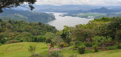
Amatitlán, Municipality near Lake Amatitlán, Guatemala.
Amatitlán is a municipality in the Guatemala Department located south of the capital city at an elevation of roughly 1,188 meters. The town occupies a region marked by residential neighborhoods and centers of local economic activity.
The municipality was founded on June 24, 1549, by Friar Diego Martínez and later established as an independent district. This status came after Central America's independence movement in the early 19th century.
The name comes from the Nahuatl language, where 'Amatl' refers to the amate tree and 'Titlan' means 'between' or 'surrounded by.' This linguistic heritage reflects the indigenous roots that shaped the region's identity.
The municipality connects to Guatemala City via the CA-9 highway, serving as a residential hub for daily commuters. Visitors should expect traffic during peak hours, as this route carries heavy daily use.
The municipality houses Guatemala's largest duty-free zone with numerous garment manufacturing facilities. This industrial sector provides substantial employment and significantly shapes the local economy.
Location: Guatemala Department
Inception: June 24, 1549
Elevation above the sea: 1,188 m
Shares border with: Villa Nueva, Santa María de Jesús, San Vicente Pacaya, Palín, Villa Canales, San Miguel Petapa
Address: Amatitlán, Guatemala
GPS coordinates: 14.47410,-90.62470
Latest update: December 20, 2025 12:26
Castillo de Dorión
4.1 km
Estadio Municipal de San Miguel Petapa
7.8 km
Finca el barretal
9.1 kmCerro La Montaña (bolkan)
5.2 kmCerro La Mariposa
1.2 kmCerro Mal Paso (bolkan)
4.5 kmCerro Chino (bolkan sa Guatemala, Departamento de Escuintla)
8.7 kmCerro Limón (bolkan)
3.8 km
Templo Josué Asambleas de Dios
9.6 kmTuricentro El Paraiso
8.3 kmPacaya
9.6 kmAtajo volcán Pacaya
8.9 kmAntenas camimo al volcán Pacaya
9.2 kmAutomariscos
5.5 kmMayan Golf Club
5.3 kmIrtra de Amatitlan
2.8 kmMayan Golf Club
5.3 kmPila Seca
7.3 kmParque
6 kmPacaya
9.4 kmMirador Laguna de Calderas
8.6 kmPrimer mirador Cerro chino
9.1 kmMirador 2 cerro chino
9.4 kmMirador 3 cerro chino
9.6 kmScenic viewpoint
2.4 kmMirador Fátima
7.8 kmScenic viewpoint
4.1 kmScenic viewpoint
4.2 kmVisited this place? Tap the stars to rate it and share your experience / photos with the community! Try now! You can cancel it anytime.
Discover hidden gems everywhere you go!
From secret cafés to breathtaking viewpoints, skip the crowded tourist spots and find places that match your style. Our app makes it easy with voice search, smart filtering, route optimization, and insider tips from travelers worldwide. Download now for the complete mobile experience.
A unique approach to discovering new places❞
— Le Figaro
All the places worth exploring❞
— France Info
A tailor-made excursion in just a few clicks❞
— 20 Minutes