·

Enable Location

We need your location to show you interesting places around you

Discover nearby places

Find interesting locations and hidden gems around you

Precise directions

Get accurate directions and distances to places

Your location is never shared with other users. It's only used when you tap the location button.

Facatativá

Log in to your account

Start exploring — it's free

Trusted by 62,649 travelers worldwide

Continue with Google
Continue with Apple
or

We will send you a code to connect

By continuing, you accept our Terms and Conditions and our Privacy Policy

Check your inbox

We've sent a pincode in your inbox. Please enter the code below.

Facatativá, Municipality in Western Savanna Province, Colombia

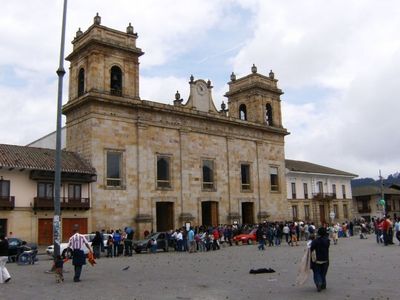
Facatativá is a municipality in the Western Savanna Province of Cundinamarca, Colombia, located 31 kilometers northwest of Bogotá. The settlement spreads across gentle hills at 2,586 meters elevation with crop fields and pastures surrounding its urban center.

Spanish administrator Diego Gómez de Mena founded the settlement on July 3, 1600, following colonial urban planning principles. During the 19th century, the town became an important agricultural center and connection point between the highland and western valleys.

The name comes from the Chibcha language of the Muisca people and means fort at the end of the plains. The central plaza retains colonial architecture with low buildings and shaded arcades where locals gather to escape the midday heat.

Main roads connect the town to Bogotá and allow regular commuter and commercial traffic along well-maintained routes. Buses run frequently during daytime, with fewer services in the evening, so planning a return before dark is advisable.

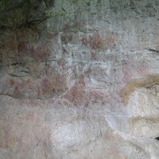
The Archaeological Park Piedras del Tunjo contains large rock formations that once formed the bottom of an ancient lake. The stones display pre-Columbian engravings showing hunting scenes and animals that the Muisca carved into the rock faces.

The community of curious travelers

AroundUs brings together thousands of curated places, local tips, and hidden gems, enriched daily by 60,000 contributors worldwide.

Start exploring
Inception
July 3, 1600
Elevation above the sea
2.586 m
GPS coordinates
4.81472,-74.35528
Latest update
December 14, 2025 17:12
« Facatativá - Municipality in Western Savanna Province, Colombia » is provided by Around Us (aroundus.com). Images and texts are derived from Wikimedia project under a Creative Commons license. You are allowed to copy, distribute, and modify copies of this page, under the conditions set by the license, as long as this note is clearly visible.

Discover hidden gems everywhere you go!

From secret cafés to breathtaking viewpoints, skip the crowded tourist spots and find places that match your style. Our app makes it easy with voice search, smart filtering, route optimization, and insider tips from travelers worldwide. Download now for the complete mobile experience.

Around Us App Screenshot

A unique approach to discovering new places

Le Figaro

All the places worth exploring

France Info

A tailor-made excursion in just a few clicks

20 Minutes

Around Us
Travel Guide & Maps
Download

Send to your phone

QR Code
1

Open the camera app on your mobile.

2

Point at the QR code with your camera. A notification will appear.

3

Tap the notification to open the link.