Chest opened
+${chestReward.xp} XP
Explorer
NOUVEAU ×${chestReward.collectible.quantity}
tapez pour fermer
Chest locked

Open chests in the app

Around Us is built for your phone — chests unlock when you walk, explore and capture nearby places.

Enable Location

We need your location to show you interesting places around you

Discover nearby places

Find interesting locations and hidden gems around you

Precise directions

Get accurate directions and distances to places

Your location is never shared with other users. It's only used when you tap the location button.

Tlalpujahua de Rayón

Log in to your account

Start exploring — it's free

Trusted by 72,982 travelers worldwide

Continue with Google
Continue with Apple
or

We will send you a code to connect

By continuing, you accept our Terms and Conditions and our Privacy Policy

Check your inbox

We've sent a pincode in your inbox. Please enter the code below.

Tlalpujahua de Rayón
Discussion Reviews 2 Photos
24.6k Popularity

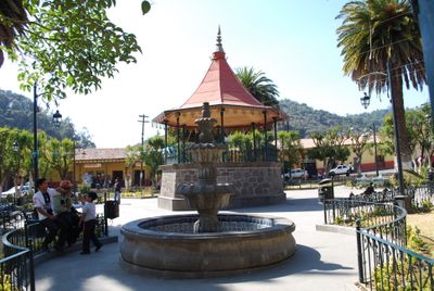
Tlalpujahua de Rayón, Colonial mountain town in Michoacán, Mexico

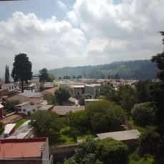
Tlalpujahua de Rayón is a mountain town in Michoacán set high on sloped terrain with narrow stone-paved streets and traditional stone buildings. The layout follows the contours of the hillside, with structures built from local materials and arranged along winding paths.

Founded in 1560, it became a significant silver mining center that operated for centuries. A major landslide in 1937 destroyed large portions and marked the beginning of an economic transformation as mining declined.

Artisans throughout the town create glass Christmas ornaments as part of their daily work, reflecting a shift in local livelihood that has shaped community identity. This craft tradition now defines how residents spend their time and what visitors come to see.

The terrain is steep and pathways are sometimes uneven, so sturdy footwear is needed for walking through town. Warm layers are helpful due to the elevation, even when daytime temperatures are mild.

A museum housed in a former mine displays equipment and photographs from the mining era, documenting how the town's economy shifted to other activities. Visitors can see how the work that sustained people for centuries gradually disappeared.

The community of curious travelers

AroundUs brings together thousands of curated places, local tips, and hidden gems, enriched daily by 60,000 contributors worldwide.

Start exploring
Inception
1560
Elevation above the sea
2,580 m
GPS coordinates
19.80523,-100.17409
Latest update
December 20, 2025 12:21
Reviews
Share your experience

No review yet

Discussions
Start a discussion...

No discussion yet

« Tlalpujahua de Rayón - Colonial mountain town in Michoacán, Mexico » is provided by Around Us (aroundus.com). Images and texts are derived from Wikimedia project under a Creative Commons license. You are allowed to copy, distribute, and modify copies of this page, under the conditions set by the license, as long as this note is clearly visible.

Discover hidden gems everywhere you go!

From secret cafés to breathtaking viewpoints, skip the crowded tourist spots and find places that match your style. Our app makes it easy with voice search, smart filtering, route optimization, and insider tips from travelers worldwide. Download now for the complete mobile experience.

Around Us App Screenshot

A unique approach to discovering new places

Le Figaro

All the places worth exploring

France Info

A tailor-made excursion in just a few clicks

20 Minutes

Around Us
Travel Guide & Maps
Download

Send to your phone

QR Code
1

Open the camera app on your mobile.

2

Point at the QR code with your camera. A notification will appear.

3

Tap the notification to open the link.