Chest opened
+${chestReward.xp} XP
Explorer
NOUVEAU ×${chestReward.collectible.quantity}
tapez pour fermer
Chest locked

Open chests in the app

Around Us is built for your phone — chests unlock when you walk, explore and capture nearby places.

Enable Location

We need your location to show you interesting places around you

Discover nearby places

Find interesting locations and hidden gems around you

Precise directions

Get accurate directions and distances to places

Your location is never shared with other users. It's only used when you tap the location button.

Lake O' the Pines

Log in to your account

Start exploring — it's free

Trusted by 72,926 travelers worldwide

Continue with Google
Continue with Apple
or

We will send you a code to connect

By continuing, you accept our Terms and Conditions and our Privacy Policy

Check your inbox

We've sent a pincode in your inbox. Please enter the code below.

Lake O' the Pines
Discussion Reviews 1 Photos
9.2k Popularity

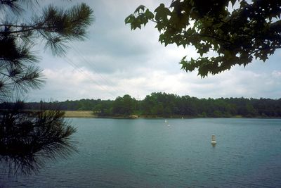
Lake O' the Pines, Reservoir in northeastern Texas, US

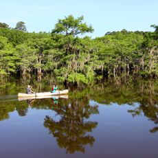
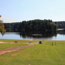
Lake O' the Pines is a reservoir in northeastern Texas formed by Ferrell's Bridge Dam across Big Cypress Creek and surrounded by dense pine forests spanning multiple counties. The water body offers multiple boat launch points and several established campgrounds for visitors seeking access to the lake.

The reservoir was created in the 1950s through construction of Ferrell's Bridge Dam on Big Cypress Creek to secure water supply and control flooding. This project was part of regional infrastructure development supporting growth in East Texas.

The lake draws fishing enthusiasts from across the region who gather for tournaments and casual outings throughout the year. This water body shapes the recreational identity of the surrounding communities.

Multiple boat ramps provide access to the water at different locations, and established campgrounds near the shoreline offer accommodation options for overnight stays. Visitors should arrive early to secure good spots, especially on weekends and during peak fishing seasons.

The lake serves as critical winter habitat for bald eagles that perch in tall pine trees along the shoreline and can be spotted by patient observers. These raptors regularly forage and rest in the area during colder months.

The community of curious travelers

AroundUs brings together thousands of curated places, local tips, and hidden gems, enriched daily by 60,000 contributors worldwide.

Start exploring
Location
GPS coordinates
32.77083,-94.54361
Latest update
December 10, 2025 15:58
Around this place
Caddo Lake State Park
United States of America

Caddo Lake State Park

35.3 km
The Grove
United States of America

The Grove

19.3 km
Daingerfield State Park
United States of America

Daingerfield State Park

30.2 km
Starr Family Home State Historic Site
United States of America

Starr Family Home State Historic Site

30.2 km
Freeman Plantation
United States of America

Freeman Plantation

16.3 km
Hotel Marshall
United States of America

Hotel Marshall

30.2 km
Old Harrison County Courthouse
United States of America

Old Harrison County Courthouse

30.1 km
The Ginocchio
United States of America

The Ginocchio

29.4 km
Cass County Courthouse
United States of America

Cass County Courthouse

31.5 km
Jefferson Historic District
United States of America

Jefferson Historic District

18.1 km
First Methodist Church
United States of America

First Methodist Church

23.2 km
Jefferson Ordnance Magazine
United States of America

Jefferson Ordnance Magazine

19.3 km
Old United States Post Office and Courts Building
United States of America

Old United States Post Office and Courts Building

18.6 km
Sam B. Hall, Jr. Federal Building and United States Courthouse
United States of America

Sam B. Hall, Jr. Federal Building and United States Courthouse

30.2 km
Ginocchio Historic District
United States of America

Ginocchio Historic District

29.6 km
Arnot House
United States of America

Arnot House

30 km
James Turner House
United States of America

James Turner House

30.4 km
Pleasant Hill School
United States of America

Pleasant Hill School

34.3 km
Hagerty House
United States of America

Hagerty House

30.2 km
Carmela's Magical Santa Land
United States of America

Carmela's Magical Santa Land

27.7 km
Presbyterian Manse
United States of America

Presbyterian Manse

18.1 km
Hochwald House
United States of America

Hochwald House

29.7 km
Fry-Barry House
United States of America

Fry-Barry House

29.9 km
Weisman-Hirsch House
United States of America

Weisman-Hirsch House

30.3 km
Historic Jefferson Railway
United States of America

Historic Jefferson Railway

19 km
Jefferson Historical Museum
United States of America

Jefferson Historical Museum

18.6 km
Paramount Theatre
United States of America

Paramount Theatre

29.9 km
Morris Theater
United States of America

Morris Theater

33.6 km
Show the full map
Reviews
Share your experience

No review yet

Discussions
Start a discussion...

No discussion yet

« Lake O' the Pines - Reservoir in northeastern Texas, US » is provided by Around Us (aroundus.com). Images and texts are derived from Wikimedia project under a Creative Commons license. You are allowed to copy, distribute, and modify copies of this page, under the conditions set by the license, as long as this note is clearly visible.

Discover hidden gems everywhere you go!

From secret cafés to breathtaking viewpoints, skip the crowded tourist spots and find places that match your style. Our app makes it easy with voice search, smart filtering, route optimization, and insider tips from travelers worldwide. Download now for the complete mobile experience.

Around Us App Screenshot

A unique approach to discovering new places

Le Figaro

All the places worth exploring

France Info

A tailor-made excursion in just a few clicks

20 Minutes

Around Us
Travel Guide & Maps
Download

Send to your phone

QR Code
1

Open the camera app on your mobile.

2

Point at the QR code with your camera. A notification will appear.

3

Tap the notification to open the link.