Enable Location

We need your location to show you interesting places around you

Discover nearby places

Find interesting locations and hidden gems around you

Precise directions

Get accurate directions and distances to places

Your location is never shared with other users. It's only used when you tap the location button.

Jenkins' Ferry Battleground State Park

Log in to your account

Start exploring — it's free

Trusted by 61,363 travelers worldwide

Continue with Google
Continue with Apple
or

We will send you a code to connect

By continuing, you accept our Terms and Conditions and our Privacy Policy

Check your inbox

We've sent a pincode in your inbox. Please enter the code below.

Jenkins' Ferry Battleground State Park, Civil War battlefield state park in Leola, United States

Description

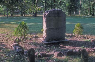
Jenkins' Ferry Battleground State Park is a 40-acre site along the Saline River with historical markers and monuments placed across the grounds. The layout helps visitors trace the positions and movements of forces during the 1864 engagement.

History

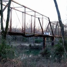
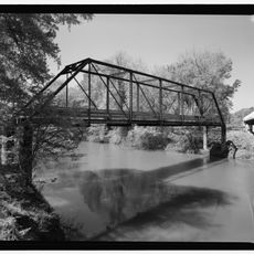
In April 1864, Union forces crossed the swollen Saline River on a pontoon bridge while under attack during a military campaign. The battle showed how critical river crossings were to the larger conflict.

Culture

The site holds monuments that reflect how this battle shaped the region and mattered deeply to both sides of the conflict. You can walk through and understand why this crossing was so strategically important to local and military history.

Practical

The grounds are straightforward to explore and include picnic areas, a pavilion, and trails along the river. Wear comfortable shoes to visit the various monuments and markers spread throughout the park.

Did you know?

The original ferry crossing established by Thomas Jenkins in 1815 still sits within the park grounds, showing that this location mattered long before the battle. Sections of an old road from before the Civil War are also still visible on the site.

Location
Inception
1961
Elevation above the sea
58 m
Part of
Arkansas Heritage Trails System
GPS coordinates
34.21306,-92.54750
Latest update
December 12, 2025 17:42

AroundUs brings together thousands of curated places, local tips, and hidden gems, enriched daily by 60,000 contributors worldwide. Discover all places nearby (Grant County).

Around this place
Old River Bridge
United States of America

Old River Bridge

36.9 km
Oak Grove School
United States of America

Oak Grove School

27.1 km
Old Benton-Sardis Road Bridge
United States of America

Old Benton-Sardis Road Bridge

38.9 km
Strauss House
United States of America

Strauss House

29.2 km
Bank of Carthage
United States of America

Bank of Carthage

15.5 km
Hot Spring County Courthouse
United States of America

Hot Spring County Courthouse

29.7 km
Bank of Malvern
United States of America

Bank of Malvern

29.6 km
Gann Building
United States of America

Gann Building

39 km
Gann House
United States of America

Gann House

39 km
Hot Springs Railroad Roundhouse
United States of America

Hot Springs Railroad Roundhouse

29.9 km
Lawyers' Row Historic District
United States of America

Lawyers' Row Historic District

29.7 km
Henry Atchley House
United States of America

Henry Atchley House

36.9 km
Prosperity Baptist Church
United States of America

Prosperity Baptist Church

37.7 km
Mt. Carmel Methodist Church
United States of America

Mt. Carmel Methodist Church

35.4 km
Mt. Zion Methodist Church
United States of America

Mt. Zion Methodist Church

17 km
Alderson-Coston House
United States of America

Alderson-Coston House

29.2 km
Koon House No. 1
United States of America

Koon House No. 1

15.3 km
Clark House
United States of America

Clark House

28.8 km
Koon House No. 6
United States of America

Koon House No. 6

14.7 km
Gann Row Historic District
United States of America

Gann Row Historic District

38.8 km
Rucker House
United States of America

Rucker House

38.3 km
Billings-Cole House
United States of America

Billings-Cole House

28.9 km
Gatewood House
United States of America

Gatewood House

29.1 km
Malvern Commercial Historic District
United States of America

Malvern Commercial Historic District

29.6 km
Glaser-Kelly House
United States of America

Glaser-Kelly House

17.3 km
Dr. John L. Butler House
United States of America

Dr. John L. Butler House

17.2 km
Samuel D. Byrd Sr. Homestead
United States of America

Samuel D. Byrd Sr. Homestead

17.8 km
Tull Bridge
United States of America

Tull Bridge

25.9 km
Show the full map
« Jenkins' Ferry Battleground State Park - Civil War battlefield state park in Leola, United States » is provided by Around Us (aroundus.com). Images and texts are derived from Wikimedia project under a Creative Commons license. You are allowed to copy, distribute, and modify copies of this page, under the conditions set by the license, as long as this note is clearly visible.

Discover hidden gems everywhere you go!

From secret cafés to breathtaking viewpoints, skip the crowded tourist spots and find places that match your style. Our app makes it easy with voice search, smart filtering, route optimization, and insider tips from travelers worldwide. Download now for the complete mobile experience.

Around Us App Screenshot

A unique approach to discovering new places

Le Figaro

All the places worth exploring

France Info

A tailor-made excursion in just a few clicks

20 Minutes

Around Us
Travel Guide & Maps
Download

Send to your phone

QR Code
1

Open the camera app on your mobile.

2

Point at the QR code with your camera. A notification will appear.

3

Tap the notification to open the link.