
Apacheta, Mountain summit in Arequipa Region, Peru.
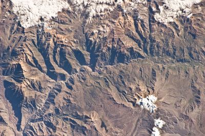
The Apacheta mountain rises to 5,328 meters within the western section of the Chila mountain range in the Andes of Peru.
The mountain location has served as a traditional crossing point for indigenous communities traveling through the Central Andean routes for centuries.
Local inhabitants construct stone cairns called apachetas at elevated points along mountain paths as offerings according to Andean spiritual traditions.
Travelers require proper altitude acclimatization and winter gear when visiting Apacheta, as temperatures frequently drop below freezing at this elevation.
The mountain stands between the Colca River and Molloco River, with its peak visible from the International Space Station orbiting Earth.
Elevation above the sea: 5,328 m
GPS coordinates: -15.38447,-72.17966
Latest update: March 11, 2025 12:35

Chilcayoc
21.1 km
P'aqu Urqu (Arequipa)
30 km
Casiri (Arequipa)
8.8 km
Condor
12.9 km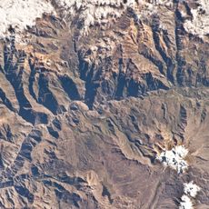
Ticlla (Castilla)
4.5 km
Yuraccacsa
7.4 km
Ticsho
24.1 km
Yanawara
32.9 km
Pumaranra
37.1 km
Usqullu
34 km
P'isqi P'isqi
30.4 km
Jechapita
21.8 km
Ch'ila
2.8 km
Surihuiri
34.3 km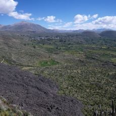
Yanamauras
21.2 km
Cerani
11.8 km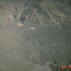
Chilcayoc Grande
20.5 km
Llallawi
31.8 km
Yuaytacondorsenja
2.2 km
Parhuayane
35.9 km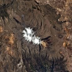
Wakapallqa
33.6 km
Choquepirhua
4.6 km
Quiscapampa
11.9 km
Ojeccasa
15.1 km
Minasniyuq
34.7 km
Airicoto
11 km
Chila Pillune
2.7 km
Asnohuañusja
4.9 kmReviews
Visited this place? Tap the stars to rate it and share your experience / photos with the community! Try now! You can cancel it anytime.
Discover hidden gems everywhere you go!
From secret cafés to breathtaking viewpoints, skip the crowded tourist spots and find places that match your style. Our app makes it easy with voice search, smart filtering, route optimization, and insider tips from travelers worldwide. Download now for the complete mobile experience.

A unique approach to discovering new places❞
— Le Figaro
All the places worth exploring❞
— France Info
A tailor-made excursion in just a few clicks❞
— 20 Minutes