Enable Location

We need your location to show you interesting places around you

Discover nearby places

Find interesting locations and hidden gems around you

Precise directions

Get accurate directions and distances to places

Your location is never shared with other users. It's only used when you tap the location button.

Antioquia District

Log in to your account

Start exploring — it's free

Trusted by 63,106 travelers worldwide

Continue with Google
Continue with Apple
or

We will send you a code to connect

By continuing, you accept our Terms and Conditions and our Privacy Policy

Check your inbox

We've sent a pincode in your inbox. Please enter the code below.

Antioquia District
Discussion Reviews 1 Photos
21.8k Popularity

Antioquia District, Administrative district in Huarochirí Province, Peru.

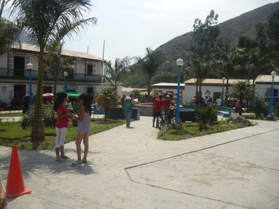
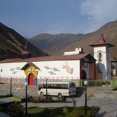
Antioquia District is an administrative unit in Huarochirí Province within Peru's Andean region, located at roughly 1,500 meters elevation across hilly terrain. The area consists of several settlements with residential buildings, agricultural fields, and pathways that form the typical structure of a highland community.

The district was officially established in 1935 and received its present administrative boundaries and governmental structures at that time. It evolved from a rural agricultural community into a formally organized territorial entity with administrative recognition.

The town displays colorful painted buildings decorated with vibrant artistic designs that transformed the village appearance. These artworks have become a defining feature of how residents and visitors experience the streets and public spaces today.

The district lies about two hours southeast of Lima via the main Javier Prado Avenue through Cieneguilla. Visitors will find regular transport options available, and should prepare for mountain roads and higher elevation conditions.

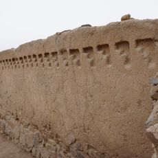
The area still contains remnants of the ancient Inca road system Qhapaq Ñan, which once connected different settlements across the region. These historical pathways remain visible today and link the modern community to its pre-colonial past.

The community of curious travelers

AroundUs brings together thousands of curated places, local tips, and hidden gems, enriched daily by 60,000 contributors worldwide.

Start exploring
Capital city
Antioquía
Elevation above the sea
1,526 m
Shares border with
Ricardo Palma District, Santa Cruz de Cocachacra District, Santiago de Tuna District, San Andrés de Tupicocha District, San Damian District, Lahuaytambo District, Cuenca District, Santo Domingo de los Olleros District, Pachacamac, Cieneguilla District, Chaclacayo District, Lurigancho-Chosica
GPS coordinates
-12.08072,-76.51061
Latest update
December 22, 2025 11:19
Reviews
Share your experience

No review yet

Discussions
Start a discussion...

No discussion yet

« Antioquia District - Administrative district in Huarochirí Province, Peru » is provided by Around Us (aroundus.com). Images and texts are derived from Wikimedia project under a Creative Commons license. You are allowed to copy, distribute, and modify copies of this page, under the conditions set by the license, as long as this note is clearly visible.

Discover hidden gems everywhere you go!

From secret cafés to breathtaking viewpoints, skip the crowded tourist spots and find places that match your style. Our app makes it easy with voice search, smart filtering, route optimization, and insider tips from travelers worldwide. Download now for the complete mobile experience.

Around Us App Screenshot

A unique approach to discovering new places

Le Figaro

All the places worth exploring

France Info

A tailor-made excursion in just a few clicks

20 Minutes

Around Us
Travel Guide & Maps
Download

Send to your phone

QR Code
1

Open the camera app on your mobile.

2

Point at the QR code with your camera. A notification will appear.

3

Tap the notification to open the link.