Taumatawhakatangihangakōauauotamateapōkaiwhenuakitānatahu

Log in to your account

AroundUs is a community-driven map of interesting places, built by curious explorers like you. It grows with every review, story, and photo you share.
Connect to save your favorite spots, contribute locations, and create personalized routes.
Continue with Google
Continue with Apple
Continue with X
Continue with Facebook
Continue with email
By continuing, you accept our Terms and Conditions and our Privacy Policy
Create an account

Taumatawhakatangihangakōauauotamateapōkaiwhenuakitānatahu

Add to collection
Map
Suggest a change
Share

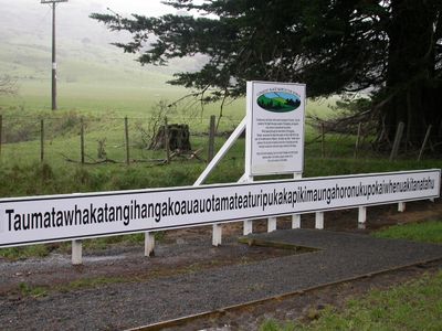
Taumatawhakatangihangakōauauotamateapōkaiwhenuakitānatahu, Summit in Hawke's Bay, New Zealand.

This summit rises 305 meters above sea level and forms an elevated point in the rural landscape of southern Hawke's Bay region. The terrain consists of sandstone formations and offers views over the surrounding hills and pastures.

The name originated from Tamatea, a warrior who played his nose flute on this summit after losing his brother in the Battle of Matanui. These events are deeply embedded in Māori oral tradition and have been passed down through generations.

The 85-letter name in Māori language tells the story of Tamatea, described as a man with large knees who traveled extensively through the land. The site carries deep importance for the local community and is respected as sacred, reflected in its Wāhi Tapu classification.

Access requires a 55-kilometer drive south from Waipukurau, followed by a turn onto Wimbledon Road leading to the name board. The site lies in rural surroundings with limited facilities, so bringing supplies is advisable.

This geographic location holds the Guinness World Record for the longest official place name in English-speaking territories with 85 characters. Visitors find a specially made sign with the full name along the access road, which has become a popular photo opportunity.

Location: Central Hawke's Bay District

Elevation above the sea: 305 m

Made from material: sandstone

GPS coordinates: -40.34606,176.54030

Latest update: December 15, 2025 10:48

Photos
Reviews

Visited this place? Tap the stars to rate it and share your experience / photos with the community! Try now! You can cancel it anytime.

« Taumatawhakatangihangakōauauotamateapōkaiwhenuakitānatahu - Summit in Hawke's Bay, New Zealand » is provided by Around Us (aroundus.com). Images and texts are derived from Wikimedia project under a Creative Commons license. You are allowed to copy, distribute, and modify copies of this page, under the conditions set by the license, as long as this note is clearly visible.

Discover hidden gems everywhere you go!

From secret cafés to breathtaking viewpoints, skip the crowded tourist spots and find places that match your style. Our app makes it easy with voice search, smart filtering, route optimization, and insider tips from travelers worldwide. Download now for the complete mobile experience.

Around Us App Screenshot

A unique approach to discovering new places

Le Figaro

All the places worth exploring

France Info

A tailor-made excursion in just a few clicks

20 Minutes