Chest opened
+${chestReward.xp} XP
Explorer
NOUVEAU ×${chestReward.collectible.quantity}
tapez pour fermer
Chest locked

Open chests in the app

Around Us is built for your phone — chests unlock when you walk, explore and capture nearby places.

Enable Location

We need your location to show you interesting places around you

Discover nearby places

Find interesting locations and hidden gems around you

Precise directions

Get accurate directions and distances to places

Your location is never shared with other users. It's only used when you tap the location button.

Montgomery Regional Airport

Log in to your account

Start exploring — it's free

Trusted by 72,880 travelers worldwide

Continue with Google
Continue with Apple
or

We will send you a code to connect

By continuing, you accept our Terms and Conditions and our Privacy Policy

Check your inbox

We've sent a pincode in your inbox. Please enter the code below.

Montgomery Regional Airport
Discussion Reviews 1 Photos
27.2k Popularity

Montgomery Regional Airport, Regional airport in Montgomery, United States.

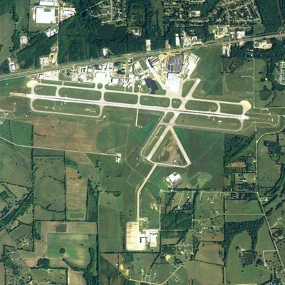
Montgomery Regional Airport is a regional facility in Montgomery, Alabama, with two asphalt runways serving commercial traffic for 16 counties across Central Alabama. The terminal provides modern amenities including free WiFi, escalators, boarding bridges, and convenient parking throughout the grounds.

The airport opened in 1943 as Dannelly Field, named after a Navy pilot who was Montgomery's first casualty of World War II. Over time, it evolved from its military roots into the regional commercial hub it is today.

The airport serves as both a civilian hub and a military installation, with the Alabama Air National Guard sharing the facility for its operations. This dual role shapes how the space functions and what you see during your visit.

The airport is well-organized and clearly marked, making it easy to find your way around. Ample parking is available, and the facility is accessible to people with different mobility needs.

The airport carries the name of Clarence Moore Dannelly Jr., a Navy pilot from Montgomery whose loss as the city's first World War II casualty left a lasting mark. This personal connection to local history adds meaning beyond just being a transportation hub.

The community of curious travelers

AroundUs brings together thousands of curated places, local tips, and hidden gems, enriched daily by 60,000 contributors worldwide.

Start exploring
Location
GPS coordinates
32.30056,-86.39389
Latest update
December 24, 2025 20:14
Around this place
Alabama Governor's Mansion
United States of America

Alabama Governor's Mansion

10.6 km
United States of America

Montgomery Motor Speedway

7.9 km
Cleveland Court Apartments 620–638
United States of America

Cleveland Court Apartments 620–638

10 km
St. Jude Educational Institute
United States of America

St. Jude Educational Institute

8.6 km
Stone Plantation
United States of America

Stone Plantation

6.3 km
Agudath Israel Etz Ahayem
United States of America

Agudath Israel Etz Ahayem

10.6 km
Garden District
United States of America

Garden District

10.5 km
Mount Zion AME Zion Church
United States of America

Mount Zion AME Zion Church

10.2 km
Simler Hall
United States of America

Simler Hall

9.7 km
McBryde-Screws-Tyson House
United States of America

McBryde-Screws-Tyson House

10.7 km
Maxwell Air Force Base Senior Officers' Quarters Historic District
United States of America

Maxwell Air Force Base Senior Officers' Quarters Historic District

10.3 km
Dr. C.A. Thigpen House
United States of America

Dr. C.A. Thigpen House

10.5 km
United States of America

Cloverdale-Idlewild

10.6 km
Opp Cottage
United States of America

Opp Cottage

10.7 km
Montgomery Whitewater
United States of America

Montgomery Whitewater

10.6 km
United States of America

Hayneville Road Park

5.9 km
United States of America

Selbrook Park

7.9 km
United States of America

Wright Flyer (Replica)

10.2 km
United States of America

Gateway Golf & Learning Center

7 km
United States of America

1Lt Karl W. Richter

10.3 km
United States of America

Republic F-105D Thunderchief

10.3 km
United States of America

North American TB-25N Mitchell

10.1 km
United States of America

North American F-100D Super Sabre

10.3 km
United States of America

McDonnell RF-101C Voodoo

10.3 km
United States of America

North American EF-86A Sabre

10.2 km
United States of America

McDonnell EF-4D Phantom II

10.3 km
United States of America

Cessna O-1A Bird Dog

9.4 km
United States of America

Northrop T-38A Talon

9.9 km
Show the full map
Reviews
Share your experience

No review yet

Discussions
Start a discussion...

No discussion yet

« Montgomery Regional Airport - Regional airport in Montgomery, United States » is provided by Around Us (aroundus.com). Images and texts are derived from Wikimedia project under a Creative Commons license. You are allowed to copy, distribute, and modify copies of this page, under the conditions set by the license, as long as this note is clearly visible.

Discover hidden gems everywhere you go!

From secret cafés to breathtaking viewpoints, skip the crowded tourist spots and find places that match your style. Our app makes it easy with voice search, smart filtering, route optimization, and insider tips from travelers worldwide. Download now for the complete mobile experience.

Around Us App Screenshot

A unique approach to discovering new places

Le Figaro

All the places worth exploring

France Info

A tailor-made excursion in just a few clicks

20 Minutes

Around Us
Travel Guide & Maps
Download

Send to your phone

QR Code
1

Open the camera app on your mobile.

2

Point at the QR code with your camera. A notification will appear.

3

Tap the notification to open the link.