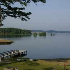
George W. Andrews Lake, body of water
George W. Andrews Lake is a reservoir on the Alabama-Georgia border along the Chattahoochee River, created by a dam built by the U.S. Army Corps of Engineers in 1963. The lake stretches approximately 26 miles, covers over 1,500 acres, and reaches depths exceeding 25 feet, with clear water suited for boating and fishing.
Originally called Columbia Lock and Dam when completed in 1963, the reservoir was renamed in 1972 to honor Congressman Andrews. The Army Corps of Engineers built it primarily to support river navigation rather than generate electricity.
The lake is named after Congressman George W. Andrews, reflecting local history. Today visitors can observe how anglers and boaters use the shoreline, particularly in early morning and late afternoon hours when fishing is most active.
Six boat ramps provide easy water access, with seven parks and camping sites spread along the 20-mile shoreline on both sides of the border. Check water level updates before boating, as levels can change quickly when the dam releases water.
The water behaves more like a flowing river channel than a still lake, with water levels dropping suddenly when the dam releases flow. Boaters and anglers often note these rapid changes, which can catch visitors off guard if they are not monitoring discharge notices.
The community of curious travelers
AroundUs brings together thousands of curated places, local tips, and hidden gems, enriched daily by 60,000 contributors worldwide.