Enable Location

We need your location to show you interesting places around you

Discover nearby places

Find interesting locations and hidden gems around you

Precise directions

Get accurate directions and distances to places

Your location is never shared with other users. It's only used when you tap the location button.

Decatur County Industrial Air Park

Log in to your account

Start exploring — it's free

Trusted by 61,679 travelers worldwide

Continue with Google
Continue with Apple
or

We will send you a code to connect

By continuing, you accept our Terms and Conditions and our Privacy Policy

Check your inbox

We've sent a pincode in your inbox. Please enter the code below.

Decatur County Industrial Air Park

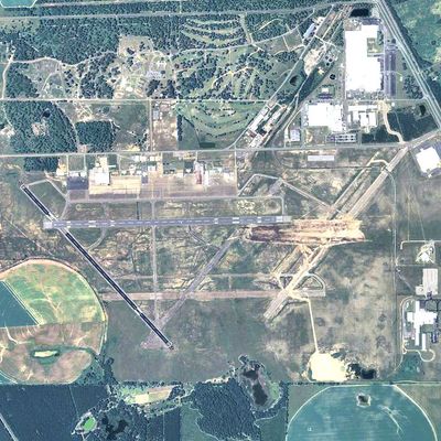
Decatur County Industrial Air Park, Public airport in Bainbridge, United States.

Description

Decatur County Industrial Air Park is a public airport serving Bainbridge and the surrounding region with facilities for general aviation and industrial flight operations. The site has two asphalt runways and infrastructure for aircraft maintenance, fuel services, and year-round business activity.

History

The facility was established in 1942 as Bainbridge Army Airfield and served as a training center for military pilots during World War II. After the war it was transformed into a civilian airport focused on industrial aviation operations.

Culture

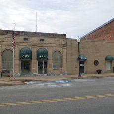
The Decatur County Museum maintains records and materials documenting the transformation from military training facility to modern industrial aviation center.

Practical

The airport offers 24-hour self-service fuel stations and aircraft maintenance services for visitors and operators. The facility operates year-round and is accessible for various types of aircraft operations and general aviation needs.

Did you know?

Several original hangars from the World War II era still stand at the facility and continue to serve modern aircraft operations. These historic structures demonstrate the long continuity of the site from its military past to present-day commercial use.

Location
GPS coordinates
30.97448,-84.61508
Latest update
December 14, 2025 09:43

AroundUs brings together thousands of curated places, local tips, and hidden gems, enriched daily by 60,000 contributors worldwide. Discover all places nearby (Decatur County).

Around this place
Lake Seminole
United States of America

Lake Seminole

37.4 km
Jim Woodruff Dam
United States of America

Jim Woodruff Dam

38 km
Leaf Theater
United States of America

Leaf Theater

43 km
Gadsden Confederate Memorial
United States of America

Gadsden Confederate Memorial

43.1 km
Quincy Library
United States of America

Quincy Library

42.8 km
Old Philadelphia Presbyterian Church
United States of America

Old Philadelphia Presbyterian Church

37 km
Ebenezer African Methodist Episcopal Church and School
United States of America

Ebenezer African Methodist Episcopal Church and School

29.1 km
First African Missionary Baptist Church
United States of America

First African Missionary Baptist Church

8.7 km
E. B. Shelfer House
United States of America

E. B. Shelfer House

42.9 km
City Hall and Firehouse
United States of America

City Hall and Firehouse

8.4 km
Quincy Historic District
United States of America

Quincy Historic District

42.8 km
Judge P. W. White House
United States of America

Judge P. W. White House

42.9 km
John Lee McFarlin House
United States of America

John Lee McFarlin House

42.9 km
Quincy Woman's Club
United States of America

Quincy Woman's Club

42.8 km
E. C. Love House
United States of America

E. C. Love House

42.9 km
U.S. Arsenal-Officers Quarters
United States of America

U.S. Arsenal-Officers Quarters

36.6 km
Stockton-Curry House
United States of America

Stockton-Curry House

43 km
Gretna School
United States of America

Gretna School

40 km
Joshua Davis House
United States of America

Joshua Davis House

33.4 km
Colquitt Town Square Historic District
United States of America

Colquitt Town Square Historic District

24.7 km
Seminole County Courthouse
United States of America

Seminole County Courthouse

26.8 km
Bainbridge Commercial Historic District
United States of America

Bainbridge Commercial Historic District

8.5 km
Decatur County Courthouse
United States of America

Decatur County Courthouse

8.4 km
J. W. Callahan House
United States of America

J. W. Callahan House

8.9 km
Donalsonville Historic District
United States of America

Donalsonville Historic District

26.6 km
Jane Donalson Harrell House
United States of America

Jane Donalson Harrell House

38.3 km
Apalachicola Arsenal Museum
United States of America

Apalachicola Arsenal Museum

36.3 km
Zebulon Theatre
United States of America

Zebulon Theatre

40.3 km
Show the full map
« Decatur County Industrial Air Park - Public airport in Bainbridge, United States » is provided by Around Us (aroundus.com). Images and texts are derived from Wikimedia project under a Creative Commons license. You are allowed to copy, distribute, and modify copies of this page, under the conditions set by the license, as long as this note is clearly visible.

Discover hidden gems everywhere you go!

From secret cafés to breathtaking viewpoints, skip the crowded tourist spots and find places that match your style. Our app makes it easy with voice search, smart filtering, route optimization, and insider tips from travelers worldwide. Download now for the complete mobile experience.

Around Us App Screenshot

A unique approach to discovering new places

Le Figaro

All the places worth exploring

France Info

A tailor-made excursion in just a few clicks

20 Minutes

Around Us
Travel Guide & Maps
Download

Send to your phone

QR Code
1

Open the camera app on your mobile.

2

Point at the QR code with your camera. A notification will appear.

3

Tap the notification to open the link.