Enable Location

We need your location to show you interesting places around you

Discover nearby places

Find interesting locations and hidden gems around you

Precise directions

Get accurate directions and distances to places

Your location is never shared with other users. It's only used when you tap the location button.

Baker County

Log in to your account

Start exploring — it's free

Trusted by 63,544 travelers worldwide

Continue with Google
Continue with Apple
or

We will send you a code to connect

By continuing, you accept our Terms and Conditions and our Privacy Policy

Check your inbox

We've sent a pincode in your inbox. Please enter the code below.

Discussion Reviews 1 Photos
30.6k Popularity

Baker County, Administrative county in North Florida, United States

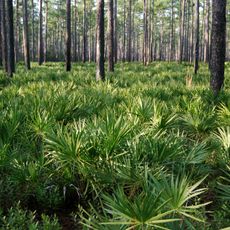
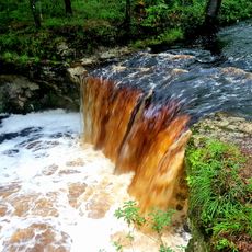
Baker County is an administrative area in North Florida covering roughly 589 square miles of land shaped by pine forests, cypress swamps, and the winding St. Mary's River that marks its eastern edge. Interstate 10 and US Highway 90 run through the county, linking it to Jacksonville and other major cities in the region.

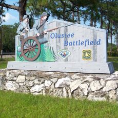
The county was established in 1861 and named after James McNair Baker, a regional leader. In 1864, it became the site of the Battle of Olustee, a major Civil War engagement that shaped the area's wartime experience.

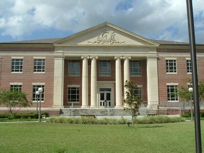
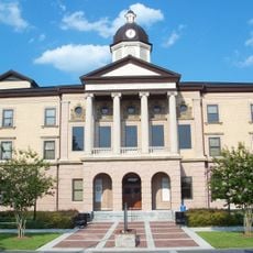
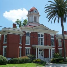
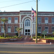
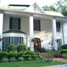
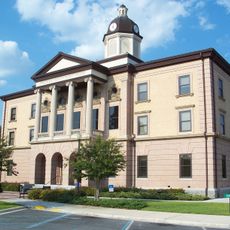
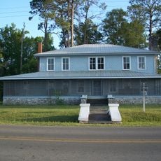
The Emily Taber Public Library occupies the restored 1908 Old Baker County Courthouse and serves as a gathering place for community programs and educational resources. The historic building remains central to local gatherings.

Two major highways, Interstate 10 and US Route 90, provide straightforward access to larger cities like Jacksonville and surrounding areas. The flat terrain and open landscape make navigation simple, and roads are well-maintained for comfortable travel.

The northern section incorporates part of the Okefenokee Swamp, one of the largest and most untamed wetlands in the eastern United States. This natural boundary creates an ecosystem where visitors encounter rare wildlife and remote wilderness rarely seen elsewhere.

The community of curious travelers

AroundUs brings together thousands of curated places, local tips, and hidden gems, enriched daily by 60,000 contributors worldwide.

Start exploring
Location
Inception
February 8, 1861
Capital city
Macclenny
Reference
12-003
Shares border with
Charlton County, Ware County, Nassau County, Duval County, Clay County, Union County, Bradford County, Columbia County, Clinch County
GPS coordinates
30.32000,-82.27000
Latest update
December 20, 2025 02:13
Around this place
Osceola National Forest
United States of America

Osceola National Forest

6 km
Olustee Battlefield Historic State Park
United States of America

Olustee Battlefield Historic State Park

18.9 km
United States of America

Cary State Forest

35.6 km
Falling Creek Falls
United States of America

Falling Creek Falls

38.8 km
Columbia County Courthouse
United States of America

Columbia County Courthouse

38 km
United States of America

Big Gum Swamp Wilderness

16.6 km
Old Baker County Courthouse
United States of America

Old Baker County Courthouse

14.9 km
Falling Creek Methodist Church and Cemetery
United States of America

Falling Creek Methodist Church and Cemetery

38.5 km
Union County Courthouse
United States of America

Union County Courthouse

33.6 km
Lake City-Columbia County Historical Museum
United States of America

Lake City-Columbia County Historical Museum

38.1 km
Glen Saint Mary Nurseries Company
United States of America

Glen Saint Mary Nurseries Company

11.7 km
Burnsed Blockhouse
United States of America

Burnsed Blockhouse

13.9 km
Lake Isabella Historic Residential District
United States of America

Lake Isabella Historic Residential District

38.1 km
Townsend Building
United States of America

Townsend Building

33.8 km
Lake City Historic Commercial District
United States of America

Lake City Historic Commercial District

38.1 km
James W. Townsend House
United States of America

James W. Townsend House

34 km
Lake Butler Woman's Club
United States of America

Lake Butler Woman's Club

33.4 km
United States of America

Goodbread-Black Farm Historic District

36.5 km
Heritage Park
United States of America

Heritage Park

13.8 km
Olustee Beach
United States of America

Olustee Beach

19.1 km
United States of America

Lake De Soto

37.8 km
United States of America

Lake Isabella

38.1 km
United States of America

Columbia Theatre

38.1 km
United States of America

Gateway Theater

38 km
United States of America

Lake Theatre

38.1 km
United States of America

Olustee Experimental Forest

21.2 km
United States of America

Scenic viewpoint

45 km
United States of America

Scenic viewpoint

45.4 km
Show the full map
Reviews
Share your experience

No review yet

Discussions
Start a discussion...

No discussion yet

Administrative divisions
« Baker County - Administrative county in North Florida, United States » is provided by Around Us (aroundus.com). Images and texts are derived from Wikimedia project under a Creative Commons license. You are allowed to copy, distribute, and modify copies of this page, under the conditions set by the license, as long as this note is clearly visible.

Discover hidden gems everywhere you go!

From secret cafés to breathtaking viewpoints, skip the crowded tourist spots and find places that match your style. Our app makes it easy with voice search, smart filtering, route optimization, and insider tips from travelers worldwide. Download now for the complete mobile experience.

Around Us App Screenshot

A unique approach to discovering new places

Le Figaro

All the places worth exploring

France Info

A tailor-made excursion in just a few clicks

20 Minutes

Around Us
Travel Guide & Maps
Download

Send to your phone

QR Code
1

Open the camera app on your mobile.

2

Point at the QR code with your camera. A notification will appear.

3

Tap the notification to open the link.