Bad Land Cliffs, cliffs in Duchesne County, Utah, United States
Location: Duchesne County
Elevation above the sea: 7,116 ft
GPS coordinates: 39.85667,-110.18639
Latest update: November 13, 2025 01:39
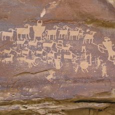
Ninemile Canyon
28.3 km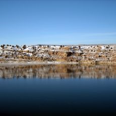
Fred Hayes State Park at Starvation
44.5 km
Indian Canyon Ranger Station
42.5 km
Starvation Reservoir
44.2 km
Argyle Canyon
15.7 km
Pariette Flood Control Dam
33.7 km
B Canyon
39.2 km
Big Canyon Rapids
26.3 km
Cedar Ridge Rapids
28.1 km
Right Fork Whitmore Canyon
31.1 km
Little Rock House Riffle
24.1 km
The Wrinkles
29.3 km
Indian Canyon
38.3 km
Grassy Trail Reservoir
31.5 km
Flat Canyon Rapids
29.1 km
Calf Canyon Rapids
38.4 km
Pace Canyon
40.1 km
Spring Canyon
31.1 km
Log Cabin Rapids
36.6 km
Firewater Rapids
27.6 km
Whitemore Canyon
37.4 km
Left Fork Whitmore Canyon
31.3 km
Rock Canyon
43.8 km
Dugout Canyon
40.3 km
West Canyon
42.7 km
Whitmore Canyon
36.9 km
Duchesne "D"
39.3 km
Scenic viewpoint
43.8 kmReviews
Visited this place? Tap the stars to rate it and share your experience / photos with the community! Try now! You can cancel it anytime.
Discover hidden gems everywhere you go!
From secret cafés to breathtaking viewpoints, skip the crowded tourist spots and find places that match your style. Our app makes it easy with voice search, smart filtering, route optimization, and insider tips from travelers worldwide. Download now for the complete mobile experience.

A unique approach to discovering new places❞
— Le Figaro
All the places worth exploring❞
— France Info
A tailor-made excursion in just a few clicks❞
— 20 Minutes