Blodgett Canyon, Canyon in Bitterroot National Forest, Montana, US
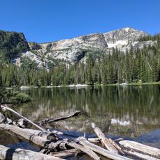
Blodgett Canyon is a glacial valley carved into granite of the Idaho Batholith, running about 12 miles northeast then east from peaks above 8,500 feet to the Bitterroot Valley near Hamilton. Its lower walls, formed by Printz Ridge and Mill Point to the north and Canyon Peak and Romney Ridge to the south, rise over 2,000 feet above Blodgett Creek. The upper section lies within the Selway-Bitterroot Wilderness.
Blodgett Canyon was cut by Ice Age glaciers into granitic rock of the Bitterroot Lobe of the Idaho Batholith, a Late Cretaceous to Paleocene intrusive body emplaced by subduction beneath western North America. The glaciers left U-shaped valleys, moraines, hanging valleys and cirques that remain visible in the canyon today. In 2000 a fire burned the forest of the lower canyon for about 2 miles above the trailhead.
The canyon lies within the aboriginal territory of the Salish (Séliš) peoples, who used the Bitterroot Valley and its eastern canyons for seasonal hunting and gathering. The name Blodgett honours a pioneer family of the Bitterroot Valley; the creek and canyon carry it today.
You can reach it by hiking from Hamilton, with the main trail leading past a waterfall and taking several hours to complete. Bring plenty of water and sturdy footwear for the rocky terrain.
The tallest route here is the South Face of Flathead Buttress, about 1,200 feet of sustained vertical climbing. The canyon is regarded among climbers as one of Montana's best big wall destinations, with walls rising over 2,000 feet above Blodgett Creek in the lower section.
The community of curious travelers
AroundUs brings together thousands of curated places, local tips, and hidden gems, enriched daily by 94,452 contributors worldwide.