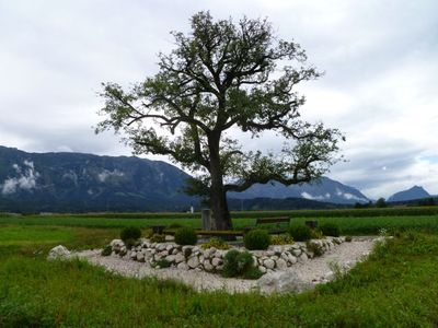
Pear tree at the Walserfeld, Historical tree in Wals-Siezenheim, Austria.
The pear tree at Walserfeld stands alone in agricultural fields, distinguishing itself with a broad canopy and sturdy trunk against the Salzburg countryside. Its age and robust form make it a notable landmark within the flat rural landscape.
The pear tree dates from the 19th century and marks the location of the Battle of Walserfeld in 1800, where French and Austrian forces clashed. This historical confrontation defined the area and remains connected to the tree's location.
The tree holds significance for local identity and has been featured on the official coat of arms of Wals-Siezenheim since 1948. Residents view it as a symbol of their community and shared heritage.
The tree sits in open fields and is easily visible during daylight, especially when approached from surrounding paths. The best time to visit is during dry weather, when field paths are accessible and the surroundings are easier to explore.
Few visitors realize that this tree was integrated into regional conservation planning and deliberately maintained as a living historical marker. The municipality implemented special protective measures to ensure this natural monument endures for future generations.
Location: Wals-Siezenheim
GPS coordinates: 47.78400,12.97330
Latest update: December 12, 2025 07:58
Hangar-7
2.8 km
Stahlwerk Annahütte
2 km
Römische Villa Loig
1.3 km
Church of the Nativity of the Virgin Mary
3.2 km
Bachschmiede
1 km
Pfarrkirche zum heiligen Georg
992 m
Kavalierhaus Kleßheim
3.9 km
Filialkirche zum heiligen Jakobus dem Älteren (Gois)
1.1 km
Pfarrkirche Leopoldskron-Moos
3.8 km
Matthäuskirche Salzburg-Taxham
3.9 km
Dreifaltigkeitskapelle
1 km
Mariae Himmelfahrt (Ainring)
2.5 km
Katholische Pfarrkirche St. Erasmus
2.7 km
Bauernhof, Wohnhaus und Stallgebäude des Klostermeierhofs
3.5 km
Rochushof (Rochuskaserne) mit Kapelle des hl. Rochus
3.6 km
Gutshof der Stieglbrauerei, Rochusmayrhof mit Kapelle
3.8 km
Kirchhof
3.2 km
Langackerer-Kapelle
3 km
Katholische Pfarrkirche Taxham
3.9 km
Moosstraße
3.8 km
Stechlgütl
3.8 km
Bildstock
1.6 km
Johannishögl 3
3.8 km
Lichtsäule auf dem Kirchhof
1.1 km
Wohnteil eines Bauernhauses
3 km
Rectory, former sacristan house
3.2 km
Erasmuskapelle
2.5 km
Ehemalige Mühle
2.2 kmVisited this place? Tap the stars to rate it and share your experience / photos with the community! Try now! You can cancel it anytime.
Discover hidden gems everywhere you go!
From secret cafés to breathtaking viewpoints, skip the crowded tourist spots and find places that match your style. Our app makes it easy with voice search, smart filtering, route optimization, and insider tips from travelers worldwide. Download now for the complete mobile experience.
A unique approach to discovering new places❞
— Le Figaro
All the places worth exploring❞
— France Info
A tailor-made excursion in just a few clicks❞
— 20 Minutes