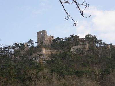
Burgruine Emmerberg, Medieval castle ruins in Winzendorf-Muthmannsdorf, Austria
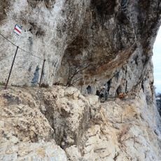
Burgruine Emmerberg stands on a 583-meter-high mountain ridge above the Prosset Gorge, with steep cliffs protecting three sides and fortified walls reinforcing the southeast face. The structure displays typical features of a medieval mountain fortress with strategically advantageous positioning.
The site was first documented in 1170 and remained under Emmerberg family control until 1455, when the male line ended and ownership passed through several noble families. These transitions shaped the fortress through subsequent centuries.
The Emmerberg coat of arms displays a water bucket on a blue field, a symbol of one of the most distinguished families in the Duchy of Styria. This emblem still shapes how visitors understand the site today.
A parking area exists near the L87 road, from which the ruins are accessible via the Eselsteig hiking trail through the forest in about 20 minutes. The path is well-marked and offers views of the surroundings during the ascent.
In 1760, Count Heinrich von Heussenstein ordered the removal of the oak roof to avoid taxes and sold the building materials. This deliberate destruction marks the beginning of the fortress's visible decline.
The community of curious travelers
AroundUs brings together thousands of curated places, local tips, and hidden gems, enriched daily by 60,000 contributors worldwide.