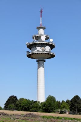
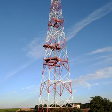
Richtfunkstation Ansfelden, Communication tower in Ansfelden, Austria.
The Richtfunkstation Ansfelden is a concrete communication tower that rises above the Upper Austrian landscape and transmits radio and television signals across the region. The structure was built using reinforced concrete and functions as part of the telecommunications network serving the area.
The tower was completed in 1978 and built to meet the growing need for telecommunications infrastructure in the Linz-Land district. Its construction marked an important moment in the region's technological development.
The tower represents a significant example of late 20th-century industrial architecture, demonstrating the integration of technology into the Austrian landscape.
The tower is visible from outside and stands out in the Ansfelden skyline as a distinctive structure in the landscape. Visitors can see it from various points in the region and use it as a landmark for orientation.
The tower combines engineering precision with architectural functionality through its reinforced concrete design, ensuring sustained transmission capabilities throughout Upper Austria.
Location: Ansfelden
Inception: 1978
Elevation above the sea: 363 m
Height: 93 m
Made from material: concrete
GPS coordinates: 48.20230,14.29300
Latest update: December 13, 2025 17:05
Anton-Bruckner-Museum
803 m
Sankt Valentin
831 m
Autobahnkirche Haid
3 km
Landwirtschaftliche Berufs- und Fachschule Ritzlhof
3.9 km
Sendeanlage Fleckendorf
1.1 km
Pfarrkirche Heiliger Vitus (Berg an der Krems)
3.9 km
Pfarrkirche Traun-St. Martin
4.5 km
Evangelische Pfarrkirche Traun
4.5 km
Burg Zierberg
2.2 km
Ansfelden City Library
3.2 km
Traunauen bei St. Martin
3 km
Golf Stärk Ansfelden
1.4 km
Friedhof Ansfelden
1.4 km
Überreste der abgekommenen Kirche St. Dionysen
3.7 km
Wegkapelle
3.5 km
Franzosenkapelle
3.5 km
Kath. Pfarrkirche Haid, ehem. Autobahnkirche (Teil in der KG Kremsdorf)
3 km
Stöttingergut
3.6 km
Pfarrhof Ansfelden
797 m
Volksschule Ansfelden
1.1 km
Pfarrhof von St. Dionysius
4.5 km
Pfarrhof Berg
3.9 km
Post und Tagesheimstätte
1.1 km
Kath. Pfarrkirche Haid, ehem. Autobahnkirche (Teil in der KG Rapperswinkel)
3 km
Bürgerhaus, Kindergarten
2.9 km
Wasserreservoir
4.4 km
Ehem. Schule
3.9 km
Linde in Berg bei Ansfelden
3.9 kmVisited this place? Tap the stars to rate it and share your experience / photos with the community! Try now! You can cancel it anytime.
Discover hidden gems everywhere you go!
From secret cafés to breathtaking viewpoints, skip the crowded tourist spots and find places that match your style. Our app makes it easy with voice search, smart filtering, route optimization, and insider tips from travelers worldwide. Download now for the complete mobile experience.
A unique approach to discovering new places❞
— Le Figaro
All the places worth exploring❞
— France Info
A tailor-made excursion in just a few clicks❞
— 20 Minutes